Filter: Categories of Wisconsin Historical Images
Filter: FULL_DATE of 1888
Filter: Subject of land
Filter: Categories of Wisconsin Historical Images
Filter: FULL_DATE of 1888
Filter: Subject of land
| Date: | 1888 |
|---|---|
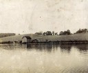
| Description: | View of shoreline along Picnic Point on the University of Wisconsin-Madison campus showing the home of Professor William Daniels, head of the Chemistry Dep... |
| Date: | 1888 |
|---|---|
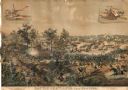
| Description: | Lithographed advertising poster showing the Civil War Battle of Atlanta. Produced for the McCormick Harvesting Machine Company, the poster features insets ... |

| Date: | 1888 |
|---|---|
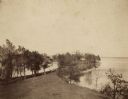
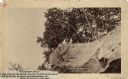
| Description: | View of Picnic Point stretching out into Lake Mendota on the University of Wisconsin-Madison campus. |
| Date: | 1888 |
|---|---|
| Description: | View of Picnic Point on the University of Wisconsin-Madison campus. The peninsula juts into Lake Mendota. The far shoreline can be seen in the distance. |
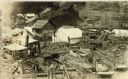
| Date: | 1888 |
|---|---|
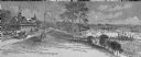
| Description: | Elevated view of clam camp with tents, clam shell debris, and wooden buildings. A bluff rises up behind the buildings. |
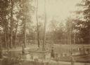
| Date: | 1888 |
|---|---|
| Description: | Several adults, two children and a dog enjoying a pond at Bracken Brae, the country home of John Johnston (1836-1904), a successful Milwaukee banker. Hilda... |
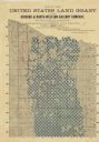
| Date: | 1888 |
|---|---|
| Description: | Map of northern Wisconsin showing the Chicago and North-Western Railway Company’s land grants within the counties of Forest, Florence, Langlade, Marinette,... |

| Date: | 1888 |
|---|---|
| Description: | This late 19th century map of Price County, Wisconsin, shows landownership and waterfront acreages, the township and range system, towns, cities and villag... |

| Date: | 1888 |
|---|---|
| Description: | Shows ward divisions and street railways, as well as University of Wisconsin buildings, churches, and schools. Cataloged from copy with right and left edge... |
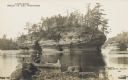
| Date: | 1888 |
|---|---|
| Description: | Photographic postcard view from shoreline of the rock formation in the Dells of the Wisconsin River. A man is paddling a canoe in the foreground. Printed o... |

| Date: | 1888 |
|---|---|
| Description: | This is a reproduction of a map originally published in 1829 by R.W. Chandler, a pioneer settler of Galena. It is based on an earlier map by surveyor Luciu... |

| Date: | 1888 |
|---|---|
| Description: | This map shows counties, lakes, railroads, and rivers. Lake Michigan, Lake Superior, and the Apostle Islands are labeled. A table of railroad lines with mi... |
| Date: | 1888 |
|---|---|
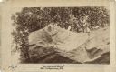
| Description: | View looking up at three men and a child on top of a cliff on which are petroglyphs. Caption on photograph reads: "Pictograph Rock. Rock bearing aboriginal... |
| Date: | 1888 |
|---|---|
| Description: | View looking up at three men and a child on top of a cliff on which are petroglyphs. Pictograph Rock bearing aboriginal carvings, located on the south side... |
If you didn't find the material you searched for, our Library Reference Staff can help.
Call our reference desk at 608-264-6535 or email us at: