 Filter: Categories of Wisconsin Historical Images
Filter: FULL_DATE of 1882
Filter: Subject of human settlements
Filter: Categories of Wisconsin Historical Images
Filter: FULL_DATE of 1882
Filter: Subject of human settlements
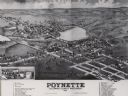
| Date: | 1882 |
|---|---|
| Description: | Bird's-eye map of Poynette, with one vignette. |

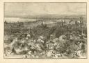
| Date: | 1882 |
|---|---|
| Description: | Bird's-eye views of various sections of Milwaukee. |

| Date: | 1882 |
|---|---|
| Description: | Bird's-eye map of Lake Geneva, looking southwest, with insets of points of interest. |

| Date: | 1882 |
|---|---|
| Description: | This map of Cedarburg is a bird's-eye map with an inset of Cedarburg Brewery. Relief is shown pictorially and the map includes an index to buildings. |
| Date: | 1882 |
|---|---|
| Description: | Bird's-eye view of Milwaukee looking south down 8th Street from Schlitz's Park. |
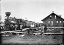
| Date: | 1882 |
|---|---|
| Description: | Group of men posing in front of the Wisconsin Central Railroad train at a depot. Railroad historian Roy L. Martin, from whose collection this image come... |

| Date: | 1882 |
|---|---|
| Description: | View of Science Hall on the University of Wisconsin Madison campus from the southwest. |
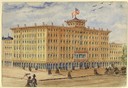
| Date: | 1882 |
|---|---|
| Description: | The magnificent Newhall House, a hotel that dwarfed the neighboring buildings, opened in 1857. Hölzlhuber completed this sketch for the Neue illustriert... |

| Date: | 1882 |
|---|---|
| Description: | Building housing the very first central electric light station for distribution of incandescent lighting. The sign on the building reads: "Vulcan St." |
| Date: | 1882 |
|---|---|
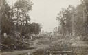
| Description: | Caption reads: "5th Ave Antigo Wis Looking West Photo taken in 1882". View down road with felled trees lining both sides. Two men are posing further down t... |
| Date: | 1882 |
|---|---|
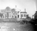
| Description: | View of excavation for the Lathrop residence, home of William H. Lathrop. |

| Date: | 1882 |
|---|---|
| Description: | This basic reference map of the state shows natural features, railroads, county seats, and political boundaries against the G.L.O. township and range grid.... |
| Date: | 1882 |
|---|---|
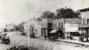
| Description: | View of Main Street business district. Horses and buggies are on the street. Some business signs read: "American and Norsk Store," "Furniture," "L....re & ... |
| Date: | 1882 |
|---|---|
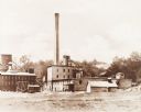
| Description: | First building of the 27th Street plant. |
| Date: | 1882 |
|---|---|
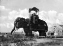
| Description: | A view of the left side of the Elephant Hotel, constructed in the shape of an elephant with small windows punctuating the side and a covered open-air obser... |
| Date: | 1882 |
|---|---|
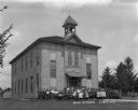
| Description: | Teachers and students pose in front of the public school. |

| Date: | 1882 |
|---|---|
| Description: | A hand-colored, sectional map of Wisconsin showing the township grid, completed and proposed railroads, counties, towns, cities, villages. The map also inc... |

| Date: | 1882 |
|---|---|
| Description: | This 1882 map of Barron County, Wisconsin, shows the township and range grid, towns, cities and villages, wagon roads, railroads, schools, dwellings, and l... |

| Date: | 1882 |
|---|---|
| Description: | Plat map of the village of Dunbarton, received by the Lafayette County Register's Office on September 22, 1892. Certification by the surveyor, Albert Pool,... |
| Date: | 1882 |
|---|---|
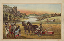
| Description: | Back cover of catalog with an illustration of two men using horse-drawn agricultural machinery in fields, while a group of Native American Indians look on.... |
If you didn't find the material you searched for, our Library Reference Staff can help.
Call our reference desk at 608-264-6535 or email us at: