 Filter: Categories of Wisconsin Historical Images
Filter: FULL_DATE of 1880
Filter: Subject of roads
Filter: Categories of Wisconsin Historical Images
Filter: FULL_DATE of 1880
Filter: Subject of roads

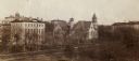
| Date: | 1880 |
|---|---|
| Description: | Stereograph. The Plankinton House is in the near foreground across the street. A sign for Little Dry Goods, 105, is on the left, above a horse-drawn cart. |
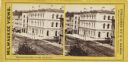
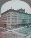
| Date: | 1880 |
|---|---|
| Description: | Stereograph. Elevated view of corner of Milwaukee and Wisconsin Streets. Three-story white building with several chimneys. A horse and cart are on the rig... |
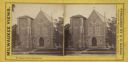
| Date: | 1880 |
|---|---|
| Description: | Stereograph. On Spring Street. Front of church along the road, with trees on each side. |
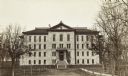
| Date: | 1880 |
|---|---|
| Description: | Elevated view across Park Street of Chadbourne Hall on the University of Wisconsin-Madison campus. Adjacent buildings (to the hall) along Park Street are,... |
| Date: | 1880 |
|---|---|
| Description: | View down Langdon Street of building at base of Bascom Hill at the intersection with Park Street. This building stood from 1876-1884. A horse and carriage ... |
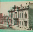
| Date: | 1880 |
|---|---|
| Description: | Stereograph of elevated view of Newhall House which was destroyed by fire in 1883. |
| Date: | 1880 |
|---|---|
| Description: | Stereograph; front of music hall along the road, with a horse and carriage team in front of the entrance. Buildings can also be seen in the left backgroun... |
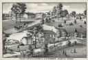
| Date: | 1880 |
|---|---|
| Description: | An illustration depicting the cheese factory and dry goods store of J.G. Pickett at Pickett's Station. |

| Date: | 1880 |
|---|---|
| Description: | A hand-colored map of the Chippewa, Price, Taylor and the northern part of Clark counties, which shows the locations of farmhouses, schoolhouses, churches,... |

| Date: | 1880 |
|---|---|
| Description: | Map of Wisconsin including the eastern portions on Minnesota, Iowa, northern Illinois, and the western most portion of Michigan’s Upper Peninsula, showing ... |

| Date: | 1880 |
|---|---|
| Description: | This 1880 map of Clark County, Wisconsin, shows the township and range grid, towns, sections, cities and villages, railroads, roads, rivers and lakes, dams... |

| Date: | 1880 |
|---|---|
| Description: | View along Central Avenue. There are a number of commercial buildings with false fronts. Groups of people stand near the road on the left and right. |
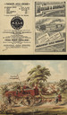
| Date: | 1880 |
|---|---|
| Description: | Front and back of 4-panel brochure. Features an illustration of the factory on the front cover. On the inside a 2-page spread features a color illustration... |

| Date: | 1880 |
|---|---|
| Description: | This map covers parts of Minnesota, Iowa, and South Dakota and advertised 1,000,000 acres of land available. Communities, roads, and railroad lines are lab... |

| Date: | 1880 |
|---|---|
| Description: | This blueprint map shows proposed railroad tracks between Carroll Street and Wisconsin Avenue along Lake Monona. |
If you didn't find the material you searched for, our Library Reference Staff can help.
Call our reference desk at 608-264-6535 or email us at: