 Filter: Categories of Wisconsin Historical Images
Filter: FULL_DATE of 1880
Filter: Subject of lakes
Filter: Subject of land
Filter: Categories of Wisconsin Historical Images
Filter: FULL_DATE of 1880
Filter: Subject of lakes
Filter: Subject of land
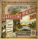
| Date: | 1880 |
|---|---|
| Description: | Cover of a McCormick Harvesting Machine Company fair circular (catalog). The cover is illustrated with a lake and mountain scene and includes the text "Man... |

| Date: | 1880 |
|---|---|
| Description: | A hand-colored map of the Chippewa, Price, Taylor and the northern part of Clark counties, which shows the locations of farmhouses, schoolhouses, churches,... |

| Date: | 1880 |
|---|---|
| Description: | Map of Wisconsin including the eastern portions on Minnesota, Iowa, northern Illinois, and the western most portion of Michigan’s Upper Peninsula, showing ... |

| Date: | 1880 |
|---|---|
| Description: | This 1880 map of Clark County, Wisconsin, shows the township and range grid, towns, sections, cities and villages, railroads, roads, rivers and lakes, dams... |
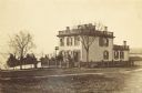
| Date: | 1880 |
|---|---|
| Description: | View across lawn of the residence of Lucius Fairchild, in Madison. A woman is standing outdoors near the entrance. A fence surrounds the yard of the house,... |
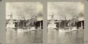
| Date: | 1880 |
|---|---|
| Description: | Elevated view across water towards an unidentified man standing on the deck of the steamship "Arrow," owned by Shelton Sturges. It is docked at a pier near... |

| Date: | 1880 |
|---|---|
| Description: | This blueprint map shows proposed railroad tracks between Carroll Street and Wisconsin Avenue along Lake Monona. |
If you didn't find the material you searched for, our Library Reference Staff can help.
Call our reference desk at 608-264-6535 or email us at: