 Filter: Categories of Wisconsin Historical Images
Filter: FULL_DATE of 1879
Filter: Subject of michigan, lake
Filter: Categories of Wisconsin Historical Images
Filter: FULL_DATE of 1879
Filter: Subject of michigan, lake

| Date: | 1879 |
|---|---|
| Description: | Bird's-eye map of Two Rivers. |

| Date: | 1879 |
|---|---|
| Description: | A map of Wisconsin as well as the southeastern most portions of Minnesota and Iowa and the Upper Peninsula of Michigan showing the township grids, railways... |

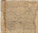
| Date: | 1879 |
|---|---|
| Description: | A map of Wisconsin showing counties, county seats, cities over 3,000 inhabitants, Lake Michigan steamship routes, railroads completed and projected, rivers... |

| Date: | 1879 |
|---|---|
| Description: | This map shows asylums, cemeteries, hospitals, parks, streets, and wards. Relief is shown by contours. Also included are manuscript annotations in pencil. ... |

| Date: | 1879 |
|---|---|
| Description: | This map shows wards, sections, roads, lot and block numbers, subdivisions, and proposed streets. The inside cover includes hand written annotations that r... |
| Date: | 1879 |
|---|---|
| Description: | This map shows names of triangulation stations, railroads, counties, rivers, and lakes. The Mississippi River, Lake Winnebago, and Lake Michigan are labele... |
If you didn't find the material you searched for, our Library Reference Staff can help.
Call our reference desk at 608-264-6535 or email us at:
