 Filter: Categories of Wisconsin Historical Images
Filter: FULL_DATE of 1879
Filter: Subject of human settlements
Filter: Categories of Wisconsin Historical Images
Filter: FULL_DATE of 1879
Filter: Subject of human settlements

| Date: | 1879 |
|---|---|
| Description: | The home of I.G. Merrill, located on the corner of Ann Street (now called Sheridan Road) and Prairie Avenue, in the winter. |
| Date: | 1879 |
|---|---|
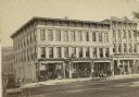
| Description: | The S.S. Kresge Company building at 25-27 East Main Street. Several businesses, including Rowley & Co., a general store, and S. Klauber dry goods, are in t... |

| Date: | 1879 |
|---|---|
| Description: | Map of Oconto and Marinette counties. |
| Date: | 1879 |
|---|---|
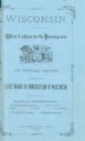
| Description: | Blue cover design of an official report entitled "Wisconsin. What It Offers to the Immigrant". |

| Date: | 1879 |
|---|---|
| Description: | Stereograph portrait of Old Abe, the mascot of the 8th Wisconsin Civil War Volunteer Infantry at the capital building. Rear view of Old Abe perched on a sh... |

| Date: | 1879 |
|---|---|
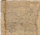
| Description: | A map of Wisconsin as well as the southeastern most portions of Minnesota and Iowa and the Upper Peninsula of Michigan showing the township grids, railways... |

| Date: | 1879 |
|---|---|
| Description: | A map of Wisconsin showing counties, county seats, cities over 3,000 inhabitants, Lake Michigan steamship routes, railroads completed and projected, rivers... |

| Date: | 1879 |
|---|---|
| Description: | A map of Jackson County, Wisconsin, shows the township and section survey, landownership, towns, villages, buildings, roads, railroads, county land, and st... |

| Date: | 1879 |
|---|---|
| Description: | This bird’s-eye-view map is a photostat copy of the orginal and is indexed for points of interest. Streets are labeled as well as the Barbaoo River. |

| Date: | 1879 |
|---|---|
| Description: | This map shows asylums, cemeteries, hospitals, parks, streets, and wards. Relief is shown by contours. Also included are manuscript annotations in pencil. ... |

| Date: | 1879 |
|---|---|
| Description: | This map shows wards, sections, roads, lot and block numbers, subdivisions, and proposed streets. The inside cover includes hand written annotations that r... |
| Date: | 1879 |
|---|---|
| Description: | This map shows names of triangulation stations, railroads, counties, rivers, and lakes. The Mississippi River, Lake Winnebago, and Lake Michigan are labele... |
If you didn't find the material you searched for, our Library Reference Staff can help.
Call our reference desk at 608-264-6535 or email us at: