 Filter: Categories of Wisconsin Historical Images
Filter: FULL_DATE of 1876
Filter: Subject of streets
Filter: Categories of Wisconsin Historical Images
Filter: FULL_DATE of 1876
Filter: Subject of streets

| Date: | 1876 |
|---|---|
| Description: | "View of the Capitol, with all the Flags" one of four "Different Views of Parades in the Streets" identified in Dahl's 1877 "Catalogue of Stereoscopic View... |
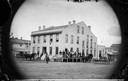
| Date: | 1876 |
|---|---|
| Description: | The Carlisle House on Brodhead Street. The building is surrounded by the Commercial Hotel, a billiard parlor, and J. Orbrecht's Variety Store. |
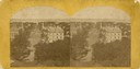
| Date: | 1876 |
|---|---|
| Description: | Elevated view from the Wisconsin State Capitol looking north to Lake Mendota along Wisconsin Avenue. City Hall is on the left, built in 1858, and the Feder... |
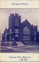
| Date: | 1876 |
|---|---|
| Description: | Front entrance to the Evangelical Church, founded in approximately 1876. |

| Date: | 1876 |
|---|---|
| Description: | This map shows existing and proposed harbor improvements, streets, the Sauk River, and Lake Michigan. On the bottom of the map inscribed in ink is: "44th C... |

| Date: | 1876 |
|---|---|
| Description: | This map is ink on tracing cloth and shows the Black River, French Slough, Little French Slough, the southern portion of North La Crosse, the Milwaukee & S... |
If you didn't find the material you searched for, our Library Reference Staff can help.
Call our reference desk at 608-264-6535 or email us at:


