 Filter: Categories of Wisconsin Historical Images
Filter: FULL_DATE of 1876
Filter: Subject of roads
Filter: Categories of Wisconsin Historical Images
Filter: FULL_DATE of 1876
Filter: Subject of roads
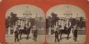
| Date: | 1876 |
|---|---|
| Description: | Stereograph. This view from East Washington Avenue shows photographer Andrew Dahl on his horse "Curnel" in front of the Wisconsin State Capitol. Dahl had j... |

| Date: | 1876 |
|---|---|
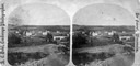
| Description: | Bird's-eye view of Black Earth. |

| Date: | 1876 |
|---|---|
| Description: | Bird's-eye view of Middleton with an inset of a school house. |
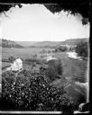
| Date: | 1876 |
|---|---|
| Description: | View, from above, of what may be the G. Gullockson farmstead. A frame house is in the left foreground, with a large group of men, women and children standi... |
| Date: | 1876 |
|---|---|
| Description: | View down a tree-lined lane to cattle drinking at a trough, a stone house and a man sitting on a fence. A home and farm buildings are in the background. |
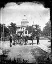
| Date: | 1876 |
|---|---|
| Description: | Issued as a stereograph on green mount entitled "The Artist." Two men stand by a wagon on which is written "A.L. Dahl Landscape Photographer." The flag on... |
| Date: | 1876 |
|---|---|
| Description: | "One view of the village of Mount Vernon, Wis." a stereograph listed in Dahl's 1877 "Catalogue of Stereoscopic Views." |

| Date: | 1876 |
|---|---|
| Description: | Originally printed in the Centennial Records of the Women of Wisconsin on page 37. The elevated view illustrates the large houses and the surrounding bustl... |
| Date: | 1876 |
|---|---|
| Description: | 462 Virginia Street. The buildings on the left are the old Melms Brewery located at the south side of the Menomonee Valley. About 1857 C.T. Melms organized... |

| Date: | 1876 |
|---|---|
| Description: | Map of home and land, with the roads, lakes, railroad, and buildings. |
| Date: | 1876 |
|---|---|
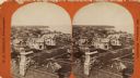
| Description: | Stereograph. Elevated view looking roughly south, the foreground overlooks a residential neighborhood. On the far shoreline, smoke clouds spew out from lar... |
| Date: | 1876 |
|---|---|
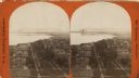
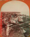
| Description: | Stereograph of a view over rooftops of a neighborhood near Lake Michigan. Shoreline can be seen in the background. |

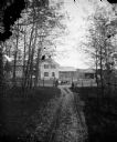
| Date: | 1876 |
|---|---|
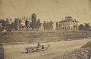
| Description: | Elevated view of building on the University of Wisconsin-Madison campus, which is located on a hill near Lake Mendota. A winding drive leads up to the hous... |
| Date: | 1876 |
|---|---|
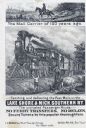
| Description: | Railroad advertising card showing a mail carrier on horseback on a plank road in 1776, and mail being delivered by train in 1876. A woman with two children... |
| Date: | 1876 |
|---|---|
| Description: | Stereograph of a view over rooftops of a neighborhood near Lake Michigan. Shoreline can be seen in the background. |

| Date: | 1876 |
|---|---|
| Description: | Detailed topographic map of the Gettysburg battlefield created thirteen years after the battle. This map shows day one of the battle. The map shows drainag... |

| Date: | 1876 |
|---|---|
| Description: | This map of the Battle of Iuka depicts the May 19, 1862, positions of the Union forces in blue and Confederate in red. Indicated on the map are roads, the ... |

| Date: | 1876 |
|---|---|
| Description: | This 1876 map of Saint Croix County, Wisconsin, shows the township and range grid, sections, towns, cities and villages, land ownership and acreages, wagon... |

| Date: | 1876 |
|---|---|
| Description: | Map shows landownership and acreages, roads and railroads, and some buildings. Includes illustrations of local buildings, business directories, and tables ... |
If you didn't find the material you searched for, our Library Reference Staff can help.
Call our reference desk at 608-264-6535 or email us at:
