 Filter: Categories of Wisconsin Historical Images
Filter: FULL_DATE of 1876
Filter: Subject of lakes
Filter: Categories of Wisconsin Historical Images
Filter: FULL_DATE of 1876
Filter: Subject of lakes

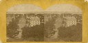
| Date: | 1876 |
|---|---|
| Description: | Bird's-eye view of Black Earth. |
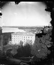
| Date: | 1876 |
|---|---|
| Description: | View from Main Hall (later Bascom Hall) on the University of Wisconsin campus. North Hall is in the foreground. Behind it is Langdon Street and, in the d... |

| Date: | 1876 |
|---|---|
| Description: | "View of the Capitol, with all the Flags" one of four "Different Views of Parades in the Streets" identified in Dahl's 1877 "Catalogue of Stereoscopic View... |
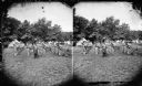
| Date: | 1876 |
|---|---|
| Description: | Quite possibly this is the "View of the Grand Music Band" listed in the "Centennial Views of the City of Madison, July 4th, 1876. Views of Chicago Light Gu... |
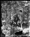
| Date: | 1876 |
|---|---|
| Description: | Four men in front of tent in the woods. There is a man with a hatchet next to a clothesline between two trees. This is a Centennial encampment on the shore... |

| Date: | 1876 |
|---|---|
| Description: | Quite possibly this is the "View of Capt. L.M. Lange's tent and seven Captains" listed in the "Centennial Views of the City of Madison, July 4th, 1876. Vie... |

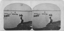
| Date: | 1876 |
|---|---|
| Description: | Three men on shoreline of Lake Mendota, one wearing a military uniform like those worn during the 1876 Centennial Celebrations in Madison. The location app... |
| Date: | 1876 |
|---|---|
| Description: | A stereograph of rowing, sailing and fishing on Lake Monona in Madison. The back of this yellow carded stereograph reads "The Beauties of Madison and Surro... |
| Date: | 1876 |
|---|---|
| Description: | Elevated view from the Wisconsin State Capitol looking north to Lake Mendota along Wisconsin Avenue. City Hall is on the left, built in 1858, and the Feder... |

| Date: | 1876 |
|---|---|
| Description: | Map of home and land, with the roads, lakes, railroad, and buildings. |

| Date: | 1876 |
|---|---|
| Description: | Elevated view of building on the University of Wisconsin-Madison campus, which is located on a hill near Lake Mendota. A winding drive leads up to the hous... |

| Date: | 1876 |
|---|---|
| Description: | A map of Wisconsin and the western portion of Michigan’s Upper Peninsula showing the township grid, counties, towns, river systems, and lakes. The borders ... |
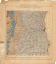
| Date: | 1876 |
|---|---|
| Description: | This color-coded map of the geology of southeastern Wisconsin shows the township grid, counties, towns, cities and villages, rivers, lakes, and railroads. ... |

| Date: | 1876 |
|---|---|
| Description: | This 1876 map of Saint Croix County, Wisconsin, shows the township and range grid, sections, towns, cities and villages, land ownership and acreages, wagon... |

| Date: | 1876 |
|---|---|
| Description: | This late 19th century map by Increase Lapham shows the lake region around Oconomowoc in Waukesha County and eastern Jefferson County, Wisconsin. Cities an... |

| Date: | 1876 |
|---|---|
| Description: | This map is of the towns of Neenah and Menasha and shows existing and proposed canals. Water depths shown by soundings. Little Butte des Morts Lake, Doty I... |

| Date: | 1876 |
|---|---|
| Description: | A hand-colored map on six sheets, this map of Juneau County indicates the locations of townships and sections, landowners and acreages, roads, wagon roads,... |

| Date: | 1876 |
|---|---|
| Description: | This map shows eastern Wisconsin, Lake Michigan, western Michigan, northeastern Illinois, and the southern part of Lake Superior. A note is included that r... |
| Date: | 1876 |
|---|---|
| Description: | This map shows mileages between rivers, lakes, and portages in Northern Wisconsin. Lake Superior is visible at the top of the map. Original caption reads, ... |
If you didn't find the material you searched for, our Library Reference Staff can help.
Call our reference desk at 608-264-6535 or email us at: