 Filter: Categories of Wisconsin Historical Images
Filter: FULL_DATE of 1876
Filter: Subject of human settlements
Filter: Categories of Wisconsin Historical Images
Filter: FULL_DATE of 1876
Filter: Subject of human settlements
| Date: | 1876 |
|---|---|
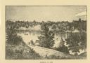
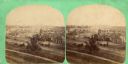
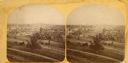
| Description: | Probably one of the "Three different views of the village of Argyle, Wis." mentioned in Dahl's 1877 "Catalogue of Stereoscopic Views." Eleven men and boys ... |
| Date: | 1876 |
|---|---|
| Description: | Probably one of the "Three different views of the village of Argyle, Wis." mentioned in Dahl's 1877 "Catalogue of Stereoscopic Views." In the foreground is... |
| Date: | 1876 |
|---|---|
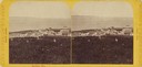
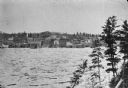
| Description: | Stereograph view of Lake Superior scenery and downtown area. |
| Date: | 1876 |
|---|---|
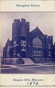
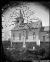
| Description: | Front entrance to the Evangelical Church, founded in approximately 1876. |
| Date: | 1876 |
|---|---|
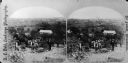
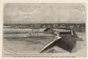
| Description: | Elevated view of Fort Howard taken from Elmore and Kelly's Elevator with the dam and river. A tugboat is in the river above the dam. Caption reads: "View o... |

| Date: | 1876 |
|---|---|
| Description: | Elevated view showing Elmore and Kelly's Elevator with a boat, train, and the buildings at Fort Howard. Fort Howard was incorporated into Green Bay. Captio... |
| Date: | 1876 |
|---|---|
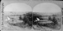
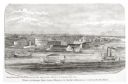
| Description: | View looking southeast over river from Elmore and Kelly's Elevator. |
| Date: | 1876 |
|---|---|
| Description: | East Blue Mounds Lutheran Church, formerly Norsk Evangelisk Kirke, built in 1868. The graves of Andreas L. Dahl's mother, Berthe Nelsdatter (Lund) Dahlen, ... |
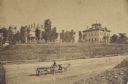
| Date: | 1876 |
|---|---|
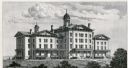
| Description: | The Institution for the Education of the Blind. |

| Date: | 1876 |
|---|---|
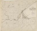
| Description: | Made from U.S. Surveys and from minutes furnished by Jos. S. Buck and Dr. C. Chase. Scale 20 CHs to an inch. |
| Date: | 1876 |
|---|---|
| Description: | Distant view of Neshotah Mission. River with boaters, two people standing on riverbank, mission on hill in background. |
| Date: | 1876 |
|---|---|
| Description: | Stereograph of artesian well, located near the intersection of Wisconsin Street and South Minnesota Street (since renamed Wacouta). |
| Date: | 1876 |
|---|---|
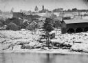
| Description: | Log jam on a high-water river, probably the Ice Gorge of 1876. |
| Date: | 1876 |
|---|---|
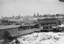
| Description: | Town and business district, showing the early covered bridge across from the tail race of the powerhouse, with logs overflowing the river into yards, proba... |
| Date: | 1876 |
|---|---|
| Description: | Logs piled on the shore of town, possibly due to Ice Gorge of 1876. |
| Date: | 1876 |
|---|---|
| Description: | Map of the area around the head of Lake Superior, including the cities of Superior and Duluth. |
| Date: | 1876 |
|---|---|
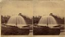
| Description: | One of "Three different views of the World's Fair at Philadelphia" mentioned in Dahl's 1877 "Catalogue of Stereoscopic Views." On the stereograph itself is... |
| Date: | 1876 |
|---|---|
| Description: | One of "Three different views of the World's Fair at Philadelphia" mentioned in Dahl's 1877 "Catalogue of Stereoscopic Views." On the stereograph itself is... |
| Date: | 1876 |
|---|---|
| Description: | 462 Virginia Street. The buildings on the left are the old Melms Brewery located at the south side of the Menomonee Valley. About 1857 C.T. Melms organized... |

| Date: | 1876 |
|---|---|
| Description: | Map of home and land, with the roads, lakes, railroad, and buildings. |
If you didn't find the material you searched for, our Library Reference Staff can help.
Call our reference desk at 608-264-6535 or email us at: