 Filter: Categories of Wisconsin Historical Images
Filter: FULL_DATE of 1875
Filter: Categories of Wisconsin Historical Images
Filter: FULL_DATE of 1875

| Date: | 1875 |
|---|---|
| Description: | This map shows Chicago Mil. & St. Paul R.R., Chicago & N.W. R.R., Wisconsin Central R.R., and other railroads. Eastern Minnesota, the upper peninsula of Mi... |
| Date: | 1875 |
|---|---|
| Description: | Elevated stereograph of the William H. Metcalf residence at the corner of Cass Street and Juneau Avenue. Trees line the street and sidewalk along the perim... |

| Date: | 1875 |
|---|---|
| Description: | Emma Seipp poses for her portrait seated on a chair holding a kitten and a small pillow in her lap. Emma is wearing a short dress with lace trim, a hat, an... |

| Date: | 1875 |
|---|---|
| Description: | A seated, full-length studio portrait in front of a painted backdrop of Sibylla Orb. She is wearing a long dress with a full skirt trimmed in lace and ruff... |
| Date: | 1875 |
|---|---|
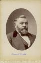
| Description: | Oval-framed quarter-length portrait of Chicago brewer Conrad Seipp (1825-1890). He is wearing a suit and vest with bow tie. The collar of the suit coat ha... |

| Date: | 1875 |
|---|---|
| Description: | Studio portrait of an unidentified woman dressed in a winter coat, hat and muff. Her coat has been turned back to reveal the ruffles on the bottom of her s... |

| Date: | 1875 |
|---|---|
| Description: | Team of oxen pulling a wagon in front of Schuette Brothers store grain warehouse on a muddy Jay Street. The man standing with the oxen is likely Fred Wilke... |
| Date: | 1875 |
|---|---|
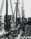
| Description: | Elevated view of a deck of a schooner hauling lumber. Several workmen are loading or unloading the lumber. Industrial buildings, some displaying signs, are... |
| Date: | 1875 |
|---|---|
| Description: | This blue line print map shows completed and proposed dams, completed and proposed shore protections, and completed spurs. The map covers the river between... |

| Date: | 1875 |
|---|---|
| Description: | The City of Fort Howard, Brown County, Wisconsin. Compiled from the records and drawn by F.E. Predergast, of De Pere. |

| Date: | 1875 |
|---|---|
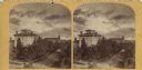
| Description: | Stereograph of the Park Hotel on the corner of Main and Carroll Streets. The Park Hotel wagon and baggage wagon are in front of the hotel. People are in fr... |

| Date: | 1875 |
|---|---|
| Description: | A portrait of Thure Kumlien which was taken at a photography studio in Stoughton. |

| Date: | 1875 |
|---|---|
| Description: | Detail from original of part of the family and the house. Original caption reads: "Halle Steensland and his wife Sophia pose with their five children (left... |

| Date: | 1875 |
|---|---|
| Description: | Detail from original of part of the family. Original caption reads: "Halle Steensland and his wife Sophia pose with their five children (left to right: Mor... |

| Date: | 1875 |
|---|---|
| Description: | Detail from original of part of the family and the house. Original caption reads: "Family posed at board fence of brick house. Two woman, one holding a par... |
| Date: | 1875 |
|---|---|
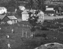
| Description: | Detail of original. Original caption reads: "A view of the village from a nearby bluff across a pond. Men, women and children, standing spaced apart, are p... |
| Date: | 1875 |
|---|---|
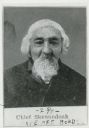
| Description: | Portrait of Chief Elijah Skenandoah, a Turtle Clan chief of the Oneida nation. He moved to Wisconsin from New York in the 1830s, along with a group of Onei... |

| Date: | 1875 |
|---|---|
| Description: | Vignetted semi-profile carte-de-visite portrait of William Adams, a theologian, educator, and co-founder of Nashotah House, an Anglican seminary. |

| Date: | 1875 |
|---|---|
| Description: | One of a set of maps from G.K. Warren's 1876 Report on the transportation route along the Wisconsin and Fox rivers in the State of Wisconsin between the Mi... |
If you didn't find the material you searched for, our Library Reference Staff can help.
Call our reference desk at 608-264-6535 or email us at:
