Filter: Categories of Wisconsin Historical Images
Filter: FULL_DATE of 1875
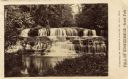
Filter: Subject of rivers
Filter: Categories of Wisconsin Historical Images
Filter: FULL_DATE of 1875
Filter: Subject of rivers

| Date: | 1875 |
|---|---|
| Description: | Bird's-eye map of Black River Falls, looking southwest. |

| Date: | 1875 |
|---|---|
| Description: | Bird's-eye map of Mazomanie. |

| Date: | 1875 |
|---|---|
| Description: | Bird's-eye map of Menomonie, with an inset of the County Court House. Spelled Menomonee on map. |

| Date: | 1875 |
|---|---|
| Description: | Bird's-eye map of Platteville. |

| Date: | 1875 |
|---|---|
| Description: | Bird's-eye map of Richland Center. |
| Date: | 1875 |
|---|---|
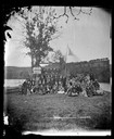
| Description: | Group portrait of the Moscow Laseselskab (the Moscow Library Association). Rasmus B. Anderson is probably in the group. |
| Date: | 1875 |
|---|---|
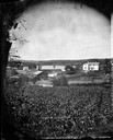
| Description: | View, through a cornfield, of people, a store, a sawmill and wagons. Moscow was platted in 1850 by an Englishman, Chauncy Smith, who dammed the Bluemound ... |
| Date: | 1875 |
|---|---|
| Description: | View of a bridge, dam and mill. Moscow was platted in 1850 by an Englishman, Chauncy Smith, who dammed the Bluemound branch of the Pecatonica River to run ... |

| Date: | 1875 |
|---|---|
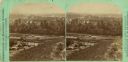
| Description: | Elevated view of a shopping district street near a river, with several businesses lining the street, and two carriages. A building across the street has le... |
| Date: | 1875 |
|---|---|
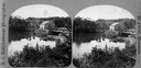
| Description: | Stereograph elevated view of a river and homes of Menomonie. |
| Date: | 1875 |
|---|---|
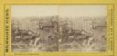
| Description: | Stereograph of Wisconsin Street looking east from Spring Street. |
| Date: | 1875 |
|---|---|
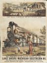
| Description: | Colored print containing two images advertising the delivery of mail. The main image is of the large Michigan and Southern train labeled "The Fast Mail" de... |

| Date: | 1875 |
|---|---|
| Description: | A hand-drawn and colored map of Wisconsin showing the railroad routs and railroad land grants La Cross and Milwaukee Railroad, St. Croix and Tomah Railroad... |

| Date: | 1875 |
|---|---|
| Description: | This hand-colored map of Wisconsin and the western portion of Michigan's Upper Peninsula depicts the township survey grid and identifies counties, named to... |
| Date: | 1875 |
|---|---|
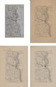
| Description: | A series of four, ink on tracing cloth maps of Milwaukee County, Wisconsin that show the topography, the Milwaukee and Menomonee rivers, and railroad of th... |

| Date: | 1875 |
|---|---|
| Description: | This manuscript map by Increase Lapham, drawn in the last year of his life, shows landownership, roads and railroads, springs, and boat houses around Ocono... |

| Date: | 1875 |
|---|---|
| Description: | This map, from G.K. Warren's 1876 Report on the transportation route along the Wisconsin and Fox rivers in the State of Wisconsin between the Mississippi R... |

| Date: | 1875 |
|---|---|
| Description: | These maps, from G.K. Warren's 1876 Report on the transportation route along the Wisconsin and Fox rivers in the State of Wisconsin between the Mississippi... |
If you didn't find the material you searched for, our Library Reference Staff can help.
Call our reference desk at 608-264-6535 or email us at: