 Filter: Categories of Wisconsin Historical Images
Filter: FULL_DATE of 1875
Filter: Subject of railroads
Filter: Categories of Wisconsin Historical Images
Filter: FULL_DATE of 1875
Filter: Subject of railroads

| Date: | 1875 |
|---|---|
| Description: | Bird's-eye map of Black River Falls, looking southwest. |

| Date: | 1875 |
|---|---|
| Description: | Bird's-eye map of Mazomanie. |

| Date: | 1875 |
|---|---|
| Description: | Bird's-eye map of Platteville. |
| Date: | 1875 |
|---|---|
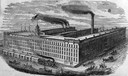
| Description: | Drawing of the C.H. & L.J. McCormick Reaper Manufactory (McCormick Reaper Works). The factory was built after the Chicago Fire of 1871 destroyed the origin... |
| Date: | 1875 |
|---|---|
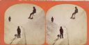
| Description: | Winter scene with three men and a dog on railroad tracks, also a man in the far background. Two of the men are up on the snowbanks with shovels. "The Grand... |
| Date: | 1875 |
|---|---|
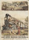
| Description: | Colored print containing two images advertising the delivery of mail. The main image is of the large Michigan and Southern train labeled "The Fast Mail" de... |

| Date: | 1875 |
|---|---|
| Description: | Winter scene with three men and a dog on railroad tracks, also a man in the far background. Two of the men are up on the snowbanks with shovels. "The Grand... |
| Date: | 1875 |
|---|---|
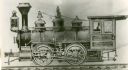
| Description: | A builder's elevation drawing of the Hinkley railroad locomotive built for the Chicago, Milwaukee, & St. Paul Railway. |

| Date: | 1875 |
|---|---|
| Description: | A hand-drawn and colored map of Wisconsin showing the railroad routs and railroad land grants La Cross and Milwaukee Railroad, St. Croix and Tomah Railroad... |

| Date: | 1875 |
|---|---|
| Description: | This manuscript map shows the limits of the land grants made to railroads in northwestern Wisconsin along the corridor between Portage and Hudson, along th... |

| Date: | 1875 |
|---|---|
| Description: | This hand-colored map of Wisconsin and the western portion of Michigan's Upper Peninsula depicts the township survey grid and identifies counties, named to... |
| Date: | 1875 |
|---|---|
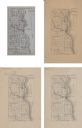
| Description: | A series of four, ink on tracing cloth maps of Milwaukee County, Wisconsin that show the topography, the Milwaukee and Menomonee rivers, and railroad of th... |

| Date: | 1875 |
|---|---|
| Description: | This manuscript map by Increase Lapham, drawn in the last year of his life, shows landownership, roads and railroads, springs, and boat houses around Ocono... |

| Date: | 1875 |
|---|---|
| Description: | These maps, from G.K. Warren's 1876 Report on the transportation route along the Wisconsin and Fox rivers in the State of Wisconsin between the Mississippi... |

| Date: | 1875 |
|---|---|
| Description: | One of a set of maps from G.K. Warren's 1876 Report on the transportation route along the Wisconsin and Fox rivers in the State of Wisconsin between the Mi... |
| Date: | 1875 |
|---|---|
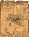
| Description: | This map shows plat of the town, land ownership by name, wards, local streets, railroads, and part of Fox River. The map also includes a directory and adve... |
| Date: | 1875 |
|---|---|
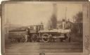
| Description: | View across railroad tracks towards a small group of men posing with Chicago & Northwestern Railway locomotive number 390 and a coal car. Dwellings and a c... |

| Date: | 1875 |
|---|---|
| Description: | This map shows Chicago Mil. & St. Paul R.R., Chicago & N.W. R.R., Wisconsin Central R.R., and other railroads. Eastern Minnesota, the upper peninsula of Mi... |
If you didn't find the material you searched for, our Library Reference Staff can help.
Call our reference desk at 608-264-6535 or email us at:
