 Filter: Categories of Wisconsin Historical Images
Filter: FULL_DATE of 1875
Filter: Subject of cities and towns
Filter: Categories of Wisconsin Historical Images
Filter: FULL_DATE of 1875
Filter: Subject of cities and towns

| Date: | 1875 |
|---|---|
| Description: | Handwritten note on back identifies this elevated view as the west side of Broadway from National Bank, looking south. The Fox River is in the background o... |
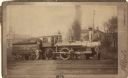
| Date: | 1875 |
|---|---|
| Description: | View across railroad tracks towards a small group of men posing with Chicago & Northwestern Railway locomotive number 390 and a coal car. Dwellings and a c... |

| Date: | 1875 |
|---|---|
| Description: | This plat map shows local streets, buildings, numbered blocks and lots, part of the Red Cedar River, and land ownership by name. Also included is a busines... |

| Date: | 1875 |
|---|---|
| Description: | This map shows Chicago Mil. & St. Paul R.R., Chicago & N.W. R.R., Wisconsin Central R.R., and other railroads. Eastern Minnesota, the upper peninsula of Mi... |
| Date: | 1875 |
|---|---|
| Description: | Elevated stereograph of the William H. Metcalf residence at the corner of Cass Street and Juneau Avenue. Trees line the street and sidewalk along the perim... |

| Date: | 1875 |
|---|---|
| Description: | Team of oxen pulling a wagon in front of Schuette Brothers store grain warehouse on a muddy Jay Street. The man standing with the oxen is likely Fred Wilke... |
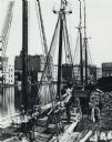
| Date: | 1875 |
|---|---|
| Description: | Elevated view of a deck of a schooner hauling lumber. Several workmen are loading or unloading the lumber. Industrial buildings, some displaying signs, are... |

| Date: | 1875 |
|---|---|
| Description: | The City of Fort Howard, Brown County, Wisconsin. Compiled from the records and drawn by F.E. Predergast, of De Pere. |

| Date: | 1875 |
|---|---|
| Description: | Stereograph of the Park Hotel on the corner of Main and Carroll Streets. The Park Hotel wagon and baggage wagon are in front of the hotel. People are in fr... |

| Date: | 1875 |
|---|---|
| Description: | Detail from original of part of the family and the house. Original caption reads: "Halle Steensland and his wife Sophia pose with their five children (left... |

| Date: | 1875 |
|---|---|
| Description: | One of a set of maps from G.K. Warren's 1876 Report on the transportation route along the Wisconsin and Fox rivers in the State of Wisconsin between the Mi... |

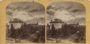
| Date: | 1875 |
|---|---|
| Description: | Elevated view of several buildings, with bridge and railroad tracks, and the Fox River. In the foreground on the right is the Commercial House, with three ... |
If you didn't find the material you searched for, our Library Reference Staff can help.
Call our reference desk at 608-264-6535 or email us at:
