Filter: Categories of Wisconsin Historical Images
Filter: FULL_DATE of 1873
Filter: Subject of transportation
Filter: Categories of Wisconsin Historical Images
Filter: FULL_DATE of 1873
Filter: Subject of transportation

| Date: | 1873 |
|---|---|
| Description: | Elevated view from Capitol Park of Madison City Hall with clock tower, 2 West Mifflin Street. Lake Mendota is in the far background. |
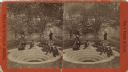
| Date: | 1873 |
|---|---|
| Description: | Stereograph of a group of men and women relaxing around a spring with concentric steps of limestone. The man on the right, holding the dipper, is Dr. Hugo ... |
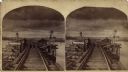
| Date: | 1873 |
|---|---|
| Description: | Stereograph of John Lawler's pile-pontoon railway bridge over both channels of the Mississippi River at Prairie du Chien and McGregor, Iowa. The East Draw ... |
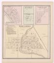
| Date: | 1873 |
|---|---|
| Description: | A page showing four plat maps: Stoughton, Clifton, Deanville, and Cross Plains. |

| Date: | 1873 |
|---|---|
| Description: | A plat map of the town of Pleasant Springs. |
If you didn't find the material you searched for, our Library Reference Staff can help.
Call our reference desk at 608-264-6535 or email us at: