Filter: Categories of Wisconsin Historical Images
Filter: FULL_DATE of 1873
Filter: Subject of human settlements
Filter: Subject of roads
Filter: Categories of Wisconsin Historical Images
Filter: FULL_DATE of 1873
Filter: Subject of human settlements
Filter: Subject of roads

| Date: | 1873 |
|---|---|
| Description: | Main Street, with its dirt, ruts, cows (and presumably manure), but wide enough for easy hitching of wagons and teams. |
| Date: | 1873 |
|---|---|
| Description: | Elevated view of railroad tracks and several houses. Several railroad employees are doing repair work on the tracks, and one man is riding on a handcar. Be... |

| Date: | 1873 |
|---|---|
| Description: | Map of the township of Windsor, from the "Atlas of Dane County." |

| Date: | 1873 |
|---|---|
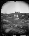
| Description: | View, ca. 1873-1879, of Madison looking down Wisconsin Avenue toward the third Wisconsin Capitol, a view that suggests something of the ongoing importance ... |
| Date: | 1873 |
|---|---|
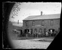
| Description: | John Parman's Blacksmith, Wagon & Carriage Shop. A large group of men, including workers in leather aprons, are standing with carriages and wagon wheels ou... |

| Date: | 1873 |
|---|---|
| Description: | View, from a distance, of Middleton. The view includes A.L. Dahl's horse-drawn wagon. |
| Date: | 1873 |
|---|---|
| Description: | View of a farmstead with multiple pine trees. A road is in foreground with a carriage driven by two horses, and a man in the carriage. A dog runs in front ... |
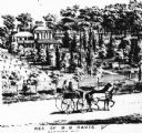
| Date: | 1873 |
|---|---|
| Description: | View of an estate covered with various plants and trees. Two people stand on a sidewalk in front of the distant estate, looking towards it. Two horses dra... |
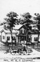
| Date: | 1873 |
|---|---|
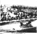
| Description: | Engraved view of the W.P. Storms residence, with a horse-drawn wagon in front traveling along the road. Caption reads: "Res. of W.P. Storms Sec 13 Spring P... |

| Date: | 1873 |
|---|---|
| Description: | Color outline map of Dane County, Wisconsin. |
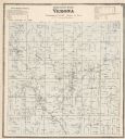
| Date: | 1873 |
|---|---|
| Description: | A map of Verona Township from the Dane County Atlas. |

| Date: | 1873 |
|---|---|
| Description: | A hand-colored map of Minnesota, Wisconsin, and Michigan shows the counties, cities, villages, rivers, lakes, railroads, and steamboat routes in these stat... |

| Date: | 1873 |
|---|---|
| Description: | A map that covers parts of Winona and Houston Counties, Minnesota and La Crosse County, Wisconsin, showing the proposed railroad routes, constructed rail l... |

| Date: | 1873 |
|---|---|
| Description: | This late 19th century map shows the lake region around Oconomowoc in Waukesha County and eastern Jefferson County, Wisconsin. The township and range grid,... |

| Date: | 1873 |
|---|---|
| Description: | This 1873 map of Chippewa County, Wisconsin, which at the time also encompassed all or part of Price, Rusk, Sawyer, and Taylor counties, shows the township... |

| Date: | 1873 |
|---|---|
| Description: | This 1874 map of Washington and Ozaukee counties, Wisconsin, shows the township and range grid, towns, sections, cities and villages, rural landownership a... |

| Date: | 1873 |
|---|---|
| Description: | This 1873 map of Winnebago County, Wisconsin, shows the township and range grid, towns, sections, cities and villages, landownership and acreages, roads, r... |

| Date: | 1873 |
|---|---|
| Description: | Map shows townships and sections, landownership and acreages, state and county lands, churches, schools, cemeteries, roads, and railroads. There is an inse... |

| Date: | 1873 |
|---|---|
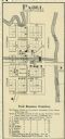
| Description: | Plat map of the township of Eagle (T5N, R17E) at a scale of 2 inches to one mile. |
If you didn't find the material you searched for, our Library Reference Staff can help.
Call our reference desk at 608-264-6535 or email us at: