 Filter: Categories of Wisconsin Historical Images
Filter: FULL_DATE of 1872
Filter: Subject of roads
Filter: Categories of Wisconsin Historical Images
Filter: FULL_DATE of 1872
Filter: Subject of roads
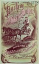
| Date: | 1872 |
|---|---|
| Description: | Cover of an advertising catalog for the Buckeye mower and reaper with self-raker manufactured by Adriance, Platt & Company. Features an illustration of a f... |

| Date: | 1872 |
|---|---|
| Description: | Birds-eye drawing of Eau Claire depicts street names and street locations, houses, trees, bridges, piers, canals, railroads, and the Chippewa and Eau Clair... |
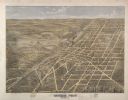
| Date: | 1872 |
|---|---|
| Description: | Bird's-eye map of Mineral Point, looking southeast. |
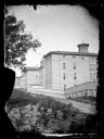
| Date: | 1872 |
|---|---|
| Description: | View of Wisconsin State Hospital for the Insane (Mendota Mental Health Institute). |
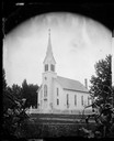
| Date: | 1872 |
|---|---|
| Description: | View from cornfield towards the Orfordville Lutheran Church, built in 1871-1872, surrounded by a white picket fence. The pastor at the time of the photogra... |

| Date: | 1872 |
|---|---|
| Description: | View across road towards the State Normal School. A fence runs along the front of the school. |
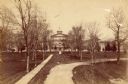
| Date: | 1872 |
|---|---|
| Description: | View from the path leading to the entrance of the Wisconsin State Hospital for the Insane (Mendota Mental Health Institute). |
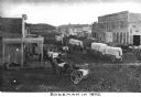
| Date: | 1872 |
|---|---|
| Description: | Elevated view of a wagon train passing through the town. There are numerous covered wagons and horses, and storefronts on both sides of the road. Caption r... |
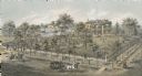
| Date: | 1872 |
|---|---|
| Description: | Lithograph elevated view of the Alexander Mitchell home and gardens seen from the corner of Ninth and Spring Streets. Pedestrians, horse-riders and a horse... |

| Date: | 1872 |
|---|---|
| Description: | This 1872 map shows the proposed route of a canal between Sturgeon Bay, on the Green Bay side of the Door Peninsula, and Lake Michigan. Depths in both Stur... |

| Date: | 1872 |
|---|---|
| Description: | Shows landowners, buildings, lot numbers, roads and railroads. Includes Menasha business directory. |

| Date: | 1872 |
|---|---|
| Description: | Shows townships and sections, landownership and acreages, roads, railroads, churches, schools, and cemeteries. Includes business directories of Manitowoc ... |

| Date: | 1872 |
|---|---|
| Description: | Map shows townships and sections, landownership, roads, railroads, churches, schools, and cemeteries. The map includes business directories of Watertown, J... |

| Date: | 1872 |
|---|---|
| Description: | This map shows wards, roads, railroads, lot and block numbers, subdivisions, parks, some landownership, and a race course. Manuscript annotations in red in... |
If you didn't find the material you searched for, our Library Reference Staff can help.
Call our reference desk at 608-264-6535 or email us at: