 Filter: Categories of Wisconsin Historical Images
Filter: FULL_DATE of 1872
Filter: Subject of land
Filter: Categories of Wisconsin Historical Images
Filter: FULL_DATE of 1872
Filter: Subject of land

| Date: | 1872 |
|---|---|
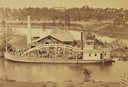
| Description: | The sidewheel packet, Red Wing, in the Mississippi River near Queen's Bluff below Trempealeau, Wisconsin. |

| Date: | 1872 |
|---|---|
| Description: | Birds-eye drawing of Eau Claire depicts street names and street locations, houses, trees, bridges, piers, canals, railroads, and the Chippewa and Eau Clair... |
| Date: | 1872 |
|---|---|
| Description: | Exterior view of the Kingsley house with family in front. It has tall and narrow double-hung windows that are grouped in twos and etched. Carpenter's lace ... |

| Date: | 1872 |
|---|---|
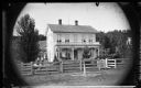
| Description: | An extended family of fifteen stands in front of a wood frame house. On the left a man holds a black horse, and to the right of the doorway a woman sits at... |
| Date: | 1872 |
|---|---|
| Description: | Elevated view from hill of the freight steamer "Cornucopia" loading hides at the Hammond Brothers warehouse, with Lawrence University buildings on the hill... |
| Date: | 1872 |
|---|---|
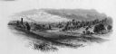
| Description: | An excerpt from "Picturesque America," ed. Bryant, (1872). |

| Date: | 1872 |
|---|---|
| Description: | Map entitled Office Wallbridge Bro. U. Sargent showing upper Minnesota and Wisconsin, as well as Lake Superior. |
| Date: | 1872 |
|---|---|
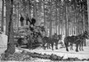
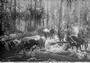
| Description: | A group of men use a team of four horses to transport logs across snow-covered ground on a sled. Trees are in the background. Caption reads: "A Logging Sce... |
| Date: | 1872 |
|---|---|
| Description: | A group of loggers poses for a group portrait amongst cut logs in a snow-covered wooded area. The men in the middle have their axes in hand, while other me... |

| Date: | 1872 |
|---|---|
| Description: | This 1872 map shows the proposed route of a canal between Sturgeon Bay, on the Green Bay side of the Door Peninsula, and Lake Michigan. Depths in both Stur... |

| Date: | 1872 |
|---|---|
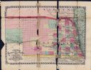
| Description: | Shows landowners, buildings, lot numbers, roads and railroads. Includes Menasha business directory. |
| Date: | 1872 |
|---|---|
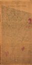
| Description: | Shows what is currently Lincoln County and portions of Vilas, Oneida, Iron, and Langlade counties. Includes manuscript annotations of marked land tracts. |

| Date: | 1872 |
|---|---|
| Description: | Shows townships and sections, landownership and acreages, roads, railroads, churches, schools, and cemeteries. Includes business directories of Manitowoc ... |

| Date: | 1872 |
|---|---|
| Description: | This map is pencil, ink, and watercolor on paper. Shown on the map is the elevation and profile of La Crescent Bottoms, Mt. Vernon Street line, 13th Street... |
| Date: | 1872 |
|---|---|
| Description: | Issued by J.M. Wolfe, publisher of Nebraska railway guide, gazetteer & directory. Publisher: Omaha, Neb. : J.M. Wolfe, 1872. Description: 1 map : hand-... |

| Date: | 1872 |
|---|---|
| Description: | This map includes depth shown by soundings and isolines and relief shown by contours. Tree species and locations are labeled, as well as a cranberry meadow... |
If you didn't find the material you searched for, our Library Reference Staff can help.
Call our reference desk at 608-264-6535 or email us at: