 Filter: Categories of Wisconsin Historical Images
Filter: FULL_DATE of 1872
Filter: Subject of cities and towns
Filter: Subject of mississippi river
Filter: Categories of Wisconsin Historical Images
Filter: FULL_DATE of 1872
Filter: Subject of cities and towns
Filter: Subject of mississippi river
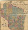
| Date: | 1872 |
|---|---|
| Description: | This map of Wisconsin depicts the township survey grid and identifies counties, named towns, cities and villages, rivers, lakes, railroads, and the Chippew... |

| Date: | 1872 |
|---|---|
| Description: | This map, which includes eastern Iowa, northern Illinois and a portion of Michigan's Upper peninsula, shows the township survey grid and identifies countie... |

| Date: | 1872 |
|---|---|
| Description: | This map is pencil, ink, and watercolor on paper. Shown on the map is the elevation and profile of La Crescent Bottoms, Mt. Vernon Street line, 13th Street... |
If you didn't find the material you searched for, our Library Reference Staff can help.
Call our reference desk at 608-264-6535 or email us at: