 Filter: Categories of Wisconsin Historical Images
Filter: FULL_DATE of 1872
Filter: Type of Map or Atlas
Filter: Subject of roads
Filter: Categories of Wisconsin Historical Images
Filter: FULL_DATE of 1872
Filter: Type of Map or Atlas
Filter: Subject of roads

| Date: | 1872 |
|---|---|
| Description: | Birds-eye drawing of Eau Claire depicts street names and street locations, houses, trees, bridges, piers, canals, railroads, and the Chippewa and Eau Clair... |
| Date: | 1872 |
|---|---|
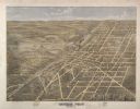
| Description: | Bird's-eye map of Mineral Point, looking southeast. |

| Date: | 1872 |
|---|---|
| Description: | This 1872 map shows the proposed route of a canal between Sturgeon Bay, on the Green Bay side of the Door Peninsula, and Lake Michigan. Depths in both Stur... |

| Date: | 1872 |
|---|---|
| Description: | Shows landowners, buildings, lot numbers, roads and railroads. Includes Menasha business directory. |

| Date: | 1872 |
|---|---|
| Description: | Shows townships and sections, landownership and acreages, roads, railroads, churches, schools, and cemeteries. Includes business directories of Manitowoc ... |

| Date: | 1872 |
|---|---|
| Description: | Map shows townships and sections, landownership, roads, railroads, churches, schools, and cemeteries. The map includes business directories of Watertown, J... |

| Date: | 1872 |
|---|---|
| Description: | This map shows wards, roads, railroads, lot and block numbers, subdivisions, parks, some landownership, and a race course. Manuscript annotations in red in... |
If you didn't find the material you searched for, our Library Reference Staff can help.
Call our reference desk at 608-264-6535 or email us at: