 Filter: Categories of Wisconsin Historical Images
Filter: FULL_DATE of 1870
Filter: Subject of lakes
Filter: Subject of land
Filter: Categories of Wisconsin Historical Images
Filter: FULL_DATE of 1870
Filter: Subject of lakes
Filter: Subject of land

| Date: | 1870 |
|---|---|
| Description: | Bird's-eye map of Hudson, with insets of Court House and Public School. |

| Date: | 1870 |
|---|---|
| Description: | Birds-eye drawing of Oconomowoc depicts street names and street layouts, houses, trees, Oconomowoc River, Fowler Lake, and La Belle Lake. A reference key a... |

| Date: | 1870 |
|---|---|
| Description: | Group of people sitting beside spring, perhaps at Winnequah or Picnic Point in Madison. All of them are either holding or are wearing hats. |

| Date: | 1870 |
|---|---|
| Description: | View from shore of sailboat anchored on the lake. There appears to be an island in the upper left. |

| Date: | 1870 |
|---|---|
| Description: | View of two lakeside cottage, which have docks and porches that overlook the lake. Caption reads: "Birch Walk, Kelly Lake, Wis." |
| Date: | 1870 |
|---|---|
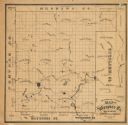
| Description: | This 1870 map of Waupaca County, Wisconsin, shows the township and range grid, towns, cities and villages, and lakes and streams. |
| Date: | 1870 |
|---|---|
| Description: | Man wearing "stove-pipe" hat, standing looking out over a lake. |
If you didn't find the material you searched for, our Library Reference Staff can help.
Call our reference desk at 608-264-6535 or email us at:
