Filter: Categories of Wisconsin Historical Images
Filter: FULL_DATE of 1870
Filter: Subject of lakes
Filter: Subject of human settlements
Filter: Categories of Wisconsin Historical Images
Filter: FULL_DATE of 1870
Filter: Subject of lakes
Filter: Subject of human settlements

| Date: | 1870 |
|---|---|
| Description: | Bird's-eye map of Hudson, with insets of Court House and Public School. |

| Date: | 1870 |
|---|---|
| Description: | Bird's-eye map of Madison. The Lakeside House resort is in the foreground, which burned in 1877, in what is now Olin Park. |

| Date: | 1870 |
|---|---|
| Description: | Birds-eye drawing of Oconomowoc depicts street names and street layouts, houses, trees, Oconomowoc River, Fowler Lake, and La Belle Lake. A reference key a... |

| Date: | 1870 |
|---|---|
| Description: | Bird's-eye view of Whitewater, with insets. |
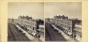
| Date: | 1870 |
|---|---|
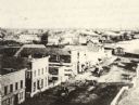
| Description: | View overlooking Pinckney Street on the Square with the American Hotel in the background. |

| Date: | 1870 |
|---|---|
| Description: | Stereograph looking south from the post office at the corner of Mifflin Street and Wisconsin Avenue across one corner of the Capitol Square toward Grace Ep... |

| Date: | 1870 |
|---|---|
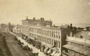
| Description: | Elevated view of City Square, where the Bank of Menasha is seen on the corner and Little Lake Butte des Mortes is in the distance. |
| Date: | 1870 |
|---|---|
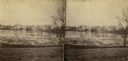
| Description: | Elevated view of Main Street looking east toward the Fox River and the boat landing. Lake Winnebago is in the distance. |
| Date: | 1870 |
|---|---|
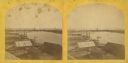
| Description: | Stereograph of an elevated view of the lumbering industry on the Fox River. Lake Winnebago is in the background. |
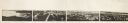
| Date: | 1870 |
|---|---|
| Description: | Panoramic view of Madison, taken from the roof of South Hall. This reduced copy was made from original negatives by E.C. Nielson. Labels for both Lake Mend... |
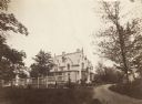
| Date: | 1870 |
|---|---|
| Description: | A large, white brick building is in the middle center, surrounded by trees. A smaller white building is in the right background. In front of the building... |
| Date: | 1870 |
|---|---|
| Description: | View overlooking Pinckney Street on the Square with the American Hotel in the background. |

| Date: | 1870 |
|---|---|
| Description: | View of two lakeside cottage, which have docks and porches that overlook the lake. Caption reads: "Birch Walk, Kelly Lake, Wis." |
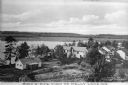
| Date: | 1870 |
|---|---|
| Description: | Elevated view of cottages along Kelly Lake's shoreline. Some of the buildings are two-story structures. Trees stand between the cottages and line the lake'... |

| Date: | 1870 |
|---|---|
| Description: | Stereograph looking south from the post office at the corner of Mifflin Street and Wisconsin Avenue across one corner of the Capitol Square toward Grace Ep... |
| Date: | 1870 |
|---|---|
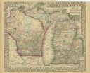
| Description: | A hand-colored map of Wisconsin and Michigan detailing the states’ rivers, lakes, counties, town and cities. The map gives the greatest length, breadth, me... |

| Date: | 1870 |
|---|---|
| Description: | Map of Wisconsin showing counties and their county seats, towns and cities with over 3,000 inhabitants, the Detroit and Milwaukee Steam Ship Line, and both... |
If you didn't find the material you searched for, our Library Reference Staff can help.
Call our reference desk at 608-264-6535 or email us at: