 Filter: Categories of Wisconsin Historical Images
Filter: FULL_DATE of 1870
Filter: Subject of industries
Filter: Categories of Wisconsin Historical Images
Filter: FULL_DATE of 1870
Filter: Subject of industries
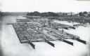
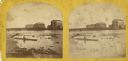
| Date: | 1870 |
|---|---|
| Description: | Elevated view of lumber raft and workers on the Chippewa River. In the background on the right are dwellings. |
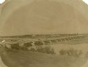
| Date: | 1870 |
|---|---|
| Description: | View from shoreline over river towards the town. |

| Date: | 1870 |
|---|---|
| Description: | Bird's-eye map of Prairie du Sac. |

| Date: | 1870 |
|---|---|
| Description: | Sauk City is the oldest incorporated village in Wisconsin (incorporated in 1854) and also has the oldest organized volunteer fire department in the state, ... |
| Date: | 1870 |
|---|---|
| Description: | Sketch of the Fox River, a train, the mill, a warehouse, and a steamboat. |
| Date: | 1870 |
|---|---|
| Description: | A stereograph of the Menasha Wooden Ware factory. |
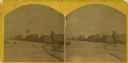
| Date: | 1870 |
|---|---|
| Description: | Stereograph view of the flour mill district. The Cedar Street Bridge is in the background, and the mills are, right to left going back, the Winnebago Flour... |
| Date: | 1870 |
|---|---|
| Description: | Dousman Warehouse, East Water Street. Originally located on the wharf parallel with the river. Built and used by George and Talbot, brothers of Hercules Do... |
| Date: | 1870 |
|---|---|
| Description: | Stereograph of an elevated view of the lumbering industry on the Fox River. Lake Winnebago is in the background. |

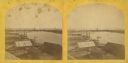
| Date: | 1870 |
|---|---|
| Description: | Stereograph of a view along the Fox River. A pier with pilings is along the right, with industrial buildings. |
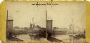
| Date: | 1870 |
|---|---|
| Description: | View of a lumber hooker ship at dock on the Root River. The 4th St. bridge spans the river at center. The Racine Woolen Mill is visible at right behind the... |

| Date: | 1870 |
|---|---|
| Description: | A map of Iowa County, Wisconsin mounted on cloth that shows the villages of Avoca, Mifflin, Linden, Arena, Helena Station, Highland, Dodgeville, as well as... |

| Date: | 1870 |
|---|---|
| Description: | This 1870 map of Brown County, Wisconsin, shows the township and range grid, towns, sections, cities, villages and post offices, land ownership, roads, rai... |

| Date: | 1870 |
|---|---|
| Description: | This map is ink and color on tracing cloth and shows Iron Ridge, the hotel and saw mill at Iron Ridge Village, Milwaukee & St. Paul Railway, plank road, an... |

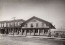
| Date: | 1870 |
|---|---|
| Description: | Elevated view of an unpaved main street, with the Village House across the street in the center background. Wooden buildings and wooden sidewalks are on bo... |
If you didn't find the material you searched for, our Library Reference Staff can help.
Call our reference desk at 608-264-6535 or email us at: