 Filter: Categories of Wisconsin Historical Images
Filter: FULL_DATE of 1870
Filter: Subject of church buildings
Filter: Year of 1800-1899
Filter: Categories of Wisconsin Historical Images
Filter: FULL_DATE of 1870
Filter: Subject of church buildings
Filter: Year of 1800-1899
| Date: | 1870 |
|---|---|
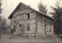
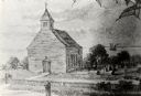
| Description: | The first Norwegian Lutheran church in Crawford County; a log structure with man standing in front. |

| Date: | 1870 |
|---|---|
| Description: | Although the first European settlement in Jefferson was in 1836, the Village of Jefferson was first incorporated as a city in 1878. Made eight years earlie... |

| Date: | 1870 |
|---|---|
| Description: | Bird's-eye map of Prairie du Sac. |

| Date: | 1870 |
|---|---|
| Description: | Sauk City is the oldest incorporated village in Wisconsin (incorporated in 1854) and also has the oldest organized volunteer fire department in the state, ... |

| Date: | 1870 |
|---|---|
| Description: | Bird's-eye view of Whitewater, with insets. |

| Date: | 1870 |
|---|---|
| Description: | Stereograph looking south from the post office at the corner of Mifflin Street and Wisconsin Avenue across one corner of the Capitol Square toward Grace Ep... |
| Date: | 1870 |
|---|---|
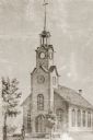
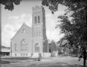
| Description: | View of a Baptist church, two small trees, and a man standing in front of the church, wearing a top hat. Baptist Church, 4th Avenue and Niagara Street, bui... |
| Date: | 1870 |
|---|---|
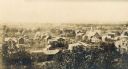
| Description: | Elevated view of the many buildings in Eau Claire's lower east side. |
| Date: | 1870 |
|---|---|
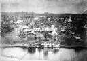
| Description: | View of the town and Chippewa river, with a steamboat in the center along the riverbank. A smaller boat is next to the steamboat, with a man standing eithe... |

| Date: | 1870 |
|---|---|
| Description: | Elevated view of the busy streets of Court and Milwaukee. Three prominent buildings in view are: Court Street Methodist Church on the far left (b. 1868), w... |
| Date: | 1870 |
|---|---|
| Description: | One of the etchings published in an atlas of Lake County, Illinios in 1870 by George Ogle. Etchings done by the Wisconsin Central Railroad. |

| Date: | 1870 |
|---|---|
| Description: | Congregational Church, also called the "old brown church" built in 1853 and burned in 1893. It was on the site of the present City Hall. The white house ne... |
| Date: | 1870 |
|---|---|
| Description: | View across street toward the exterior of Immanuel's Kirche dur Evangelical German church. All the arched windows are decorated with stained glass, mostly ... |

| Date: | 1870 |
|---|---|
| Description: | Stereograph looking south from the post office at the corner of Mifflin Street and Wisconsin Avenue across one corner of the Capitol Square toward Grace Ep... |

| Date: | 1870 |
|---|---|
| Description: | A map of Iowa County, Wisconsin mounted on cloth that shows the villages of Avoca, Mifflin, Linden, Arena, Helena Station, Highland, Dodgeville, as well as... |
If you didn't find the material you searched for, our Library Reference Staff can help.
Call our reference desk at 608-264-6535 or email us at:

