 Filter: Categories of Wisconsin Historical Images
Filter: FULL_DATE of 1870
Filter: Subject of bridges
Filter: Categories of Wisconsin Historical Images
Filter: FULL_DATE of 1870
Filter: Subject of bridges
| Date: | 1870 |
|---|---|
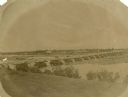
| Description: | View from shoreline over river towards the town. |

| Date: | 1870 |
|---|---|
| Description: | During the War of 1812, the only battle fought in Wisconsin was in Prairie du Chien, in 1814. Made fifty-six years later, this birds eye drawing depicts th... |

| Date: | 1870 |
|---|---|
| Description: | Bird's-eye map of Prairie du Sac. |

| Date: | 1870 |
|---|---|
| Description: | Sauk City is the oldest incorporated village in Wisconsin (incorporated in 1854) and also has the oldest organized volunteer fire department in the state, ... |

| Date: | 1870 |
|---|---|
| Description: | Bird's-eye view of the city of Manitowoc with a population of 5,168 inhabitants as it appears in 1870, the year the village was granted a city charter by t... |

| Date: | 1870 |
|---|---|
| Description: | Bird's-eye view of Whitewater, with insets. |

| Date: | 1870 |
|---|---|
| Description: | Five piece panoramic view of the Green Bay waterfront area. |

| Date: | 1870 |
|---|---|
| Description: | View from along right side of bridge of Milwaukee Street looking east in Janesville. The Myers House is located at the top of the hill. There is a sign for... |
| Date: | 1870 |
|---|---|
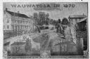
| Description: | An advertisement featuring Wauwatosa, showing the First Baptist Church, on the left, built in 1854 and the First Congregational Church, on the right built ... |
| Date: | 1870 |
|---|---|
| Description: | View across water towards the Habheger's Bowling Park at the North Fourth Street bridge. A group of people are standing on the bridge. |

| Date: | 1870 |
|---|---|
| Description: | The corner of unpaved Main Street and Tayco Street looking south towards Doty Island. The slanting timbers controlled the primitive draw bridge across the ... |
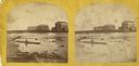
| Date: | 1870 |
|---|---|
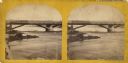
| Description: | Stereograph view of Cedar Street Bridge(?) with a rocky shoreline on the left. The construction of this bridge is the same as the Cedar Street bridge, but ... |
| Date: | 1870 |
|---|---|
| Description: | Stereograph view of the flour mill district. The Cedar Street Bridge is in the background, and the mills are, right to left going back, the Winnebago Flour... |

| Date: | 1870 |
|---|---|
| Description: | Stereograph of flour mill district. The Walnut Street bridge is in the background and the mill to the right is the Atlantic Mills (Neenah Stone Mills in 18... |

| Date: | 1870 |
|---|---|
| Description: | Stereograph of Main Street viewed from the bridge. The Revere House is just beyond the bridge on the right, and on the left is a sign on the side of a buil... |
If you didn't find the material you searched for, our Library Reference Staff can help.
Call our reference desk at 608-264-6535 or email us at:


