 Filter: Categories of Wisconsin Historical Images
Filter: FULL_DATE of 1869
Filter: Subject of cities and towns
Filter: Categories of Wisconsin Historical Images
Filter: FULL_DATE of 1869
Filter: Subject of cities and towns
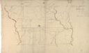
| Date: | 1869 |
|---|---|
| Description: | Hand-drawn map of York County, South Carolina. |
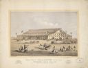
| Date: | 1869 |
|---|---|
| Description: | A lithograph of the Coliseum for the Grand National Peace Jubilee in Boston, Massachusetts on June 15-19. |
| Date: | 1869 |
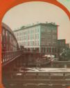
|---|---|
| Description: | Stereograph of the Axtell House building, with a storefront next to it advertising "Clothing Hats Caps Sailors Outfits". A bridge is on the left and a man... |
| Date: | 1869 |
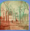
|---|---|
| Description: | Stereograph of a chapel on the campus of Racine College with a man standing in front of it. |

| Date: | 1869 |
|---|---|
| Description: | This geological map shows the township grid, counties, cities and villages, rivers, lakes, railroads, and roads. Barron County is still labeled Dallas Coun... |

| Date: | 1869 |
|---|---|
| Description: | This map was engraved from original drawings and surveys taken by Louis Lipman. Includes Milwaukee street directory on the left hand side. Bottom right cor... |

| Date: | 1869 |
|---|---|
| Description: | Map shows townships and sections, landownership and acreages, buildings, and marshes. The map includes insets of Franklin, Hales Corners, Bay View, Oak Cre... |

| Date: | 1869 |
|---|---|
| Description: | This map shows lot and block numbers, some property ownership, wards, roads, and railroads and includes inset map of Glidden & Lockwood’s addition. There a... |
If you didn't find the material you searched for, our Library Reference Staff can help.
Call our reference desk at 608-264-6535 or email us at: