 Filter: Categories of Wisconsin Historical Images
Filter: FULL_DATE of 1865
Filter: Subject of streets
Filter: Categories of Wisconsin Historical Images
Filter: FULL_DATE of 1865
Filter: Subject of streets
| Date: | 1865 |
|---|---|
| Description: | University of Wisconsin-Madison campus showing the first three buildings on campus, South Hall (left), University Hall [Bascom Hall] (center), and North Ha... |
| Date: | 1865 |
|---|---|
| Description: | First block of West Main Street. A portion of South Hamilton Street is at the right of the image. The original railroad causeway is at the upper right. |

| Date: | 1865 |
|---|---|
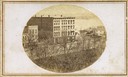
| Description: | Elevated view of the Congregational church and surrounding buildings. |
| Date: | 1865 |
|---|---|
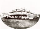
| Description: | The first Eau Claire House built in 1856. It burned down in 1875. |

| Date: | 1865 |
|---|---|
| Description: | Milwaukee Street looking west. In the foreground is a dog standing on a bridge. Signs on a building on the right read: "Furniture" and "Valley Chief Reaper... |
| Date: | 1865 |
|---|---|
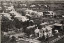
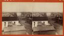
| Description: | Aerial view of a residential part of Janesville. |

| Date: | 1865 |
|---|---|
| Description: | Elevated view of Milwaukee Street. |
| Date: | 1865 |
|---|---|
| Description: | Stereograph of an elevated view of Court House Square in Lancaster. |

| Date: | 1865 |
|---|---|
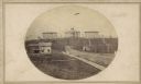
| Description: | Harvey Hospital, or the Soldiers' Orphans Home. The main octagon section was the home of Governor Farwell, and the wing of wood was added in 1862 and used ... |
| Date: | 1865 |
|---|---|
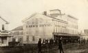
| Description: | Kane's Hotel, built in about 1839 by Ezekiel Tainter, and then called the Phoenix Hotel, on Main Street. It passed through many hands but retained the orig... |

| Date: | 1865 |
|---|---|
| Description: | This detailed map of the area between Richmond and Petersburg shows fortifications, roads, railroads, towns, street patterns of Petersburg and Richmond, dr... |

| Date: | 1865 |
|---|---|
| Description: | This is a collection of two plat maps. The first map shows lots, streets, and farm lot 25. Written in ink, the top of the map reads: Plat of Prairie du Chi... |
If you didn't find the material you searched for, our Library Reference Staff can help.
Call our reference desk at 608-264-6535 or email us at: