 Filter: Categories of Wisconsin Historical Images
Filter: FULL_DATE of 1864
Filter: Subject of human settlements
Filter: Subject of transportation
Filter: Categories of Wisconsin Historical Images
Filter: FULL_DATE of 1864
Filter: Subject of human settlements
Filter: Subject of transportation
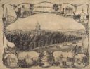
| Date: | 1864 |
|---|---|
| Description: | Bird's-eye view of Madison, with 12 vignettes and in the center is "The Capitol of Wisconsin View from the Capitol House". The buildings on the top are, fr... |
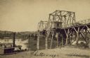
| Date: | 1864 |
|---|---|
| Description: | Carte-de-visite of a bridge at Chattanooga with a steamship passing nearby. |
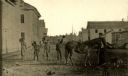
| Date: | 1864 |
|---|---|
| Description: | View looking north up Third Street near Market Square. There are five boys and a horse in the middle of the road. |

| Date: | 1864 |
|---|---|
| Description: | Map reads: "Johnson's Wisconsin and Michigan". There is a decorative border, a scale of which ten miles is approximately one inch and individual counties d... |
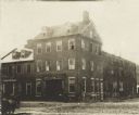
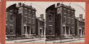
| Date: | 1864 |
|---|---|
| Description: | Marshall House, in which Col. E.E. Ellsworth was shot on May 24, 1861. |

| Date: | 1864 |
|---|---|
| Description: | View across the Tennessee River toward the city and Cameron Hill, showing the military bridge and some Union Army installations put up following the occupa... |
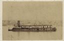
| Date: | 1864 |
|---|---|
| Description: | Union gunboat "Prairie Bird," a small rear-wheel steamship. |
| Date: | 1864 |
|---|---|
| Description: | A stereograph of exterior of General Lee's residence. |
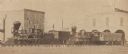
| Date: | 1864 |
|---|---|
| Description: | The locomotives "Christopher Adams" and "Liverpool," taken over and operated by the U.S. military during the Civil War. |
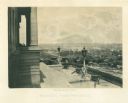
| Date: | 1864 |
|---|---|
| Description: | View down capitol building steps, where cannons sit on a landing, and statues decorate two lampposts. The city spreads out far below. Plate 03 |

| Date: | 1864 |
|---|---|
| Description: | This map of the Atlanta area shows entrenchments, relief by hachures, vegetation, drainage, roads, railroads, towns, and the names of a few residents in th... |

| Date: | 1864 |
|---|---|
| Description: | This colored map shows cities, rail lines, and geographic features in eastern Virginia. Circles around Richmond at 10 mile intervals indicate distances fro... |

| Date: | 1864 |
|---|---|
| Description: | This battlefield map of the Battle of Totopotomoy Creek, also known as the Battle of Bethesda Church, shows the railroads, roads, vegetation and topography... |

| Date: | 1864 |
|---|---|
| Description: | This battlefield map of the Battle of Totopotomoy Creek, also known as the Battle of Bethesda Church, shows the railroads, roads, vegetation and topography... |

| Date: | 1864 |
|---|---|
| Description: | This map depicts the positions of Union forces, in blue, and Confederate forces, in red, at the end of 1863 after the cessation of the Knoxville Campaign. ... |

| Date: | 1864 |
|---|---|
| Description: | This map of the area of the First Battle of Bull Run shows military positions and troop movements as well as the names of landowners, vegetation and land u... |

| Date: | 1864 |
|---|---|
| Description: | This map created during the Civil War indicates Confederate fortifications, houses, names of residents, towns, roads, railroads, relief by hachures, draina... |

| Date: | 1864 |
|---|---|
| Description: | Map of eastern Virginia and part of Maryland, showing engagements by crossed swords, fortifications surrounding Richmond, routes of the opposing armies fro... |
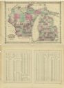
| Date: | 1864 |
|---|---|
| Description: | A map of Wisconsin and Michigan showing the counties, named towns, cities and villages, and railroads. The opposite side includes a lists counties with pop... |
If you didn't find the material you searched for, our Library Reference Staff can help.
Call our reference desk at 608-264-6535 or email us at:
