 Filter: Categories of Wisconsin Historical Images
Filter: FULL_DATE of 1863
Filter: Subject of land
Filter: Categories of Wisconsin Historical Images
Filter: FULL_DATE of 1863
Filter: Subject of land
| Date: | 1863 |
|---|---|
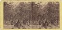
| Description: | Stereograph of Gettysburg battlefield showing trees and a stump. Handwritten on reverse, "On the right of our line." This is probably a reference to the te... |

| Date: | 1863 |
|---|---|
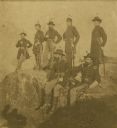
| Description: | Union army officers. From left are: General U.S. Grant, General Rawlins, General Webster, Colonel Lagow, and Colonel Killyer take a break. |
| Date: | 1863 |
|---|---|
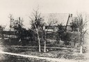
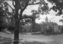
| Description: | Exterior of St. John Chrysostom Episcopal Church, with trees and a fence in the foreground. |
| Date: | 1863 |
|---|---|
| Description: | The Twenty-First Wisconsin Volunteer Infantry posing on Lookout Mountain. From right to left: Fred W. Borcherdt of Manitowoc, Wisconsin; acting Adjutant Co... |

| Date: | 1863 |
|---|---|
| Description: | Map of the west end of Lake Superior, including Superior, St. Louis, and Allouez Bays. |
| Date: | 1863 |
|---|---|
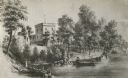
| Description: | View of the shoreline on the Walker Castle grounds. Two men are boating while a young boy fishes from the shore. |
| Date: | 1863 |
|---|---|
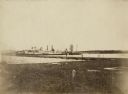
| Description: | View from shoreline of the side-wheel steamship "Thomas Powell," probably in southern waters. Industrial buildings are in the background. |

| Date: | 1863 |
|---|---|
| Description: | A map of Illinois showing all railroads, stations, and towns. |
| Date: | 1863 |
|---|---|
| Description: | View down hill across lawn toward a three-story building with a cupola at the bottom of the hill on the Ripon College campus. Caption reads: "View across t... |

| Date: | 1863 |
|---|---|
| Description: | This map shows roads, railroads, settlements, farms with owners' names, vegetation, streams, and fords in Culpeper County region during the Civil War. A ma... |

| Date: | 1863 |
|---|---|
| Description: | This map illustrates the position of Fort Hindman at Arkansas Post on the Arkansas River. Depicted are the positions of Confederate defenses as well ships ... |

| Date: | 1863 |
|---|---|
| Description: | This map is a hand-colored, pen and ink, drawing by Ole R. Dahl of Co. B, 15 Wisconsin Infantry shows the battlefield at Stones River, depicting roads, str... |

| Date: | 1863 |
|---|---|
| Description: | These detailed topographical maps of the Battle of Gettysburg show drainage, vegetation, roads, railroads, fences, houses with names of residents, and a de... |

| Date: | 1863 |
|---|---|
| Description: | These detailed topographical maps of the Battle of Gettysburg show drainage, vegetation, roads, railroads, fences, houses with names of residents, and a de... |

| Date: | 1863 |
|---|---|
| Description: | This colored map of the Battle of Chattanooga depicts the positions of the Union and Confederate troops before the battle and on each day of the battle. Al... |

| Date: | 1863 |
|---|---|
| Description: | This map shows drainage, vegetation, roads, railroads, fences, dwellings with names of inhabitants, and land owned by the United States. Union and Confeder... |
| Date: | 1863 |
|---|---|
| Description: | This map depicts the opening battles in the Union campaign against Vicksburg, Mississippi, in May 1863. Noted are the Battle of Port Gibson, May 1, 1863, t... |

| Date: | 1863 |
|---|---|
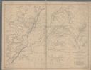
| Description: | A general map of the southeastern United States showing Missouri, Kentucky, West Virginia, Virginia, North Carolina, South Carolina, Georgia, Florida, Alab... |

| Date: | 1863 |
|---|---|
| Description: | This map of the Battle of Chattanooga depicts roads, railroads, drainage, vegetation, relief, and the names of residents in the outlying areas. Fourteen Wi... |
| Date: | 1863 |
|---|---|
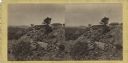
| Description: | Stereograph of breast works on a rocky outcropping on the site of the Battle of Gettysburg. A man can be seen standing behind the breast works. He is gazin... |
If you didn't find the material you searched for, our Library Reference Staff can help.
Call our reference desk at 608-264-6535 or email us at: