 Filter: Categories of Wisconsin Historical Images
Filter: FULL_DATE of 1863
Filter: Subject of human settlements
Filter: Subject of transportation
Filter: Subject of land
Filter: Categories of Wisconsin Historical Images
Filter: FULL_DATE of 1863
Filter: Subject of human settlements
Filter: Subject of transportation
Filter: Subject of land
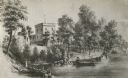
| Date: | 1863 |
|---|---|
| Description: | View of the shoreline on the Walker Castle grounds. Two men are boating while a young boy fishes from the shore. |

| Date: | 1863 |
|---|---|
| Description: | A map of Illinois showing all railroads, stations, and towns. |

| Date: | 1863 |
|---|---|
| Description: | These detailed topographical maps of the Battle of Gettysburg show drainage, vegetation, roads, railroads, fences, houses with names of residents, and a de... |

| Date: | 1863 |
|---|---|
| Description: | This map shows drainage, vegetation, roads, railroads, fences, dwellings with names of inhabitants, and land owned by the United States. Union and Confeder... |

| Date: | 1863 |
|---|---|
| Description: | This map of the Battle of Chattanooga depicts roads, railroads, drainage, vegetation, relief, and the names of residents in the outlying areas. Fourteen Wi... |
| Date: | 1863 |
|---|---|
| Description: | This plat map of Brillion is ink and pencil on paper. The front of the map shows a plat of the town, roads, and Spring Creek, and includes a significant ha... |
If you didn't find the material you searched for, our Library Reference Staff can help.
Call our reference desk at 608-264-6535 or email us at: