 Filter: Categories of Wisconsin Historical Images
Filter: FULL_DATE of 1863
Filter: Subject of human settlements
Filter: Subject of dwellings
Filter: Categories of Wisconsin Historical Images
Filter: FULL_DATE of 1863
Filter: Subject of human settlements
Filter: Subject of dwellings

| Date: | 1863 |
|---|---|
| Description: | View across street towards Senator Philetus Sawyer's residence. Sawyer was elected to the U.S. Senate in 1881. People are posing in horse-drawn vehicles in... |
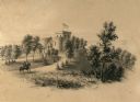
| Date: | 1863 |
|---|---|
| Description: | A view overlooking the grounds towards the Benjamin Walker Castle, 1862-1893 in the 900 block of East Gorham Street, and its surrounding property. A man is... |

| Date: | 1863 |
|---|---|
| Description: | View of the grounds of Benjamin Walker Castle, 1862-1893 in the 900 block of East Gorham Street. |
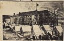
| Date: | 1863 |
|---|---|
| Description: | A heavily retouched photographic view of Libby Prison. This view shows tents and three tenement (loft style) buildings. |
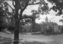
| Date: | 1863 |
|---|---|
| Description: | View down hill across lawn toward a three-story building with a cupola at the bottom of the hill on the Ripon College campus. Caption reads: "View across t... |

| Date: | 1863 |
|---|---|
| Description: | View of the gymnasium at Northwestern College. A staircase leads up the terraced hill to the brick building. |

| Date: | 1863 |
|---|---|
| Description: | This map shows roads, railroads, settlements, farms with owners' names, vegetation, streams, and fords in Culpeper County region during the Civil War. A ma... |

| Date: | 1863 |
|---|---|
| Description: | These detailed topographical maps of the Battle of Gettysburg show drainage, vegetation, roads, railroads, fences, houses with names of residents, and a de... |

| Date: | 1863 |
|---|---|
| Description: | These detailed topographical maps of the Battle of Gettysburg show drainage, vegetation, roads, railroads, fences, houses with names of residents, and a de... |

| Date: | 1863 |
|---|---|
| Description: | This map shows drainage, vegetation, roads, railroads, fences, dwellings with names of inhabitants, and land owned by the United States. Union and Confeder... |
If you didn't find the material you searched for, our Library Reference Staff can help.
Call our reference desk at 608-264-6535 or email us at: