 Filter: Categories of Wisconsin Historical Images
Filter: FULL_DATE of 1862
Filter: Subject of land
Filter: Subject of transportation
Filter: Categories of Wisconsin Historical Images
Filter: FULL_DATE of 1862
Filter: Subject of land
Filter: Subject of transportation

| Date: | 1862 |
|---|---|
| Description: | An image from a sketchbook of "The Gunboats at No. 10 — Eve of Arrival before the I'sld". The drawing appears to be from the deck of a ship showing several... |

| Date: | 1862 |
|---|---|
| Description: | Lithography of C. Van Benthuysen. |

| Date: | 1862 |
|---|---|
| Description: | This map of the Battle of Shiloh shows relief by hachures, vegetation, drainage, houses, fields, fences, mills, and roads and is color coded to show the mo... |

| Date: | 1862 |
|---|---|
| Description: | This map of the southeastern United States shows cities and towns, rail lines, and geographic features such as rivers, mountains, lakes, and swamps. |

| Date: | 1862 |
|---|---|
| Description: | This map of the southeastern United States shows forts and battlefields, railroads, rivers, and cities and towns. Dates of admission and secession of the s... |
| Date: | 1862 |
|---|---|
| Description: | This map of the area between Monterey, Tennessee, and Corinth, Mississippi, shows Union lines of entrenchment in blue and Confederate lines around Corinth ... |

| Date: | 1862 |
|---|---|
| Description: | This map of eastern Virginia and Maryland shows rivers, roads and railroads from Hagerstown, Maryland, south to Suffolk, Virginia, and west to Staunton, Vi... |

| Date: | 1862 |
|---|---|
| Description: | This detailed map shows batteries and rifle pits, railroads, common and military roads, turnpikes, city streets and names, bridges, ferries, rural houses a... |
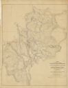
| Date: | 1862 |
|---|---|
| Description: | This map shows townships, landownership, roads, railroads, and swampland in Jefferson County. There is an inset maps showing the towns of: Watertown, Jeffe... |

| Date: | 1862 |
|---|---|
| Description: | This 1862 map of Sheboygan County, Wisconsin, shows land ownership and acreages, the township and range grid, towns, cities and villages, roads, railroads,... |

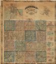
| Date: | 1862 |
|---|---|
| Description: | This map shows townships and sections, landownership and acreages, roads, railroads, cemeteries, churches, schools, mills, and stone quarries. "Engraved, p... |

| Date: | 1862 |
|---|---|
| Description: | Shows townships and sections, landownership and acreage, roads, railroads, churches, schools, and cemeteries. Inset maps: Plat of Hingham -- Plat of Casca... |
If you didn't find the material you searched for, our Library Reference Staff can help.
Call our reference desk at 608-264-6535 or email us at: