 Filter: Categories of Wisconsin Historical Images
Filter: FULL_DATE of 1862
Filter: Subject of civil war, 1861-1865
Filter: Year of 1800-1899
Filter: Categories of Wisconsin Historical Images
Filter: FULL_DATE of 1862
Filter: Subject of civil war, 1861-1865
Filter: Year of 1800-1899
| Date: | 1862 |
|---|---|
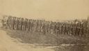
| Description: | Company I, 7th Regiment Wisconsin Volunteer Infantry, at Upton's Hill near Germantown, Virginia. The 7th was one of three Wisconsin regiments that was part... |
| Date: | 1862 |
|---|---|
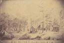
| Description: | Sketch of the camp of the 15th Regiment of the Wisconsin Volunteer Infantry on Island No. 10 during the Civil War. Colonel Hans Christian Heg commanded the... |

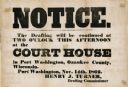
| Date: | 1862 |
|---|---|
| Description: | Poster calling for volunteers for the Civil War, claiming "Highest Bounty And Pay!". |
| Date: | 1862 |
|---|---|
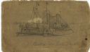
| Description: | The USS "Benton" was an "ironclad" ship which served as Capt. Andrew Hull Foote's flagship during the March 1862 assault on Island No. 10. |

| Date: | 1862 |
|---|---|
| Description: | Quarter-length portrait of Harriet Rhoads at the time of her marriage to Lieutenant D.G. Hudson of Camp Douglas, Chicago, Illinois (1862). |
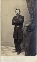
| Date: | 1862 |
|---|---|
| Description: | Carte-de-visite portrait of Lucius Fairchild in his uniform as lieutenant colonel of the 2nd Wisconsin Infantry by the Brady studio. |

| Date: | 1862 |
|---|---|
| Description: | Portrait of Knut Iversen Vike, Company F, 15th Wisconsin Infantry, in his Civil War uniform. The following information is in the published Roster of Wiscon... |
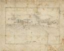
| Date: | 1862 |
|---|---|
| Description: | A small amateur drawing of the camp, with surrounding terrain, occupied by the 104th Regiment, New York State Volunteers near Belle Plains, Virginia, durin... |
| Date: | 1862 |
|---|---|
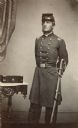
| Description: | Full-length carte-de-visite portrait of Captain Lewis S. Burton, Company B, 30th Wisconsin Infantry, standing in full uniform with his sword on his left si... |
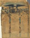
| Date: | 1862 |
|---|---|
| Description: | Civil War Union Army recruitment handbill. |
| Date: | 1862 |
|---|---|
| Description: | Lithographed poster by Lipman of Milwaukee. |

| Date: | 1862 |
|---|---|
| Description: | This map illustrates the official plan for the siege of Yorktown, Virginia, and indicates the headquarters of Generals McClellan, Porter, Woodbury, and Hei... |

| Date: | 1862 |
|---|---|
| Description: | This map shows the region of southeastern Virginia which served as the setting for the Peninsular Campaign of 1862. A few battle sites are marked by crosse... |

| Date: | 1862 |
|---|---|
| Description: | This map of the Battle of Shiloh shows relief by hachures, vegetation, drainage, houses, fields, fences, mills, and roads and is color coded to show the mo... |

| Date: | 1862 |
|---|---|
| Description: | This map of the Mississippi River between Island No. 8, northeast of New Madrid, Missouri, and Tiptonville, Tennessee, depicts the Confederate defenses at ... |

| Date: | 1862 |
|---|---|
| Description: | This map of the southeastern United States shows forts and battlefields, railroads, rivers, and cities and towns. Dates of admission and secession of the s... |
| Date: | 1862 |
|---|---|
| Description: | This map of the area between Monterey, Tennessee, and Corinth, Mississippi, shows Union lines of entrenchment in blue and Confederate lines around Corinth ... |

| Date: | 1862 |
|---|---|
| Description: | This map of eastern Virginia and Maryland shows rivers, roads and railroads from Hagerstown, Maryland, south to Suffolk, Virginia, and west to Staunton, Vi... |

| Date: | 1862 |
|---|---|
| Description: | This pen and ink drawing of the First Battle of Bull Run, JuIy 21st, 1861, was made by Charles K. Dean, adjutant with the 2nd Wisconsin Infantry. The 2nd W... |

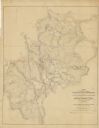
| Date: | 1862 |
|---|---|
| Description: | The first in a series of three maps of the Virginia Peninsula. This map details the area from Williamsburg south to Fortress Monroe at Hampton Roads and sh... |
If you didn't find the material you searched for, our Library Reference Staff can help.
Call our reference desk at 608-264-6535 or email us at: