 Filter: Categories of Wisconsin Historical Images
Filter: FULL_DATE of 1862
Filter: Subject of civil war, 1861-1865
Filter: Subject of dwellings
Filter: Categories of Wisconsin Historical Images
Filter: FULL_DATE of 1862
Filter: Subject of civil war, 1861-1865
Filter: Subject of dwellings

| Date: | 1862 |
|---|---|
| Description: | Camp Randall looking southwest. In April 1861, Governor Alexander Randall asked that the State Agricultural Society fairgrounds be converted into a militar... |
| Date: | 1862 |
|---|---|
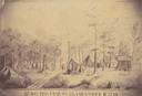
| Description: | Sketch of the camp of the 15th Regiment of the Wisconsin Volunteer Infantry on Island No. 10 during the Civil War. Colonel Hans Christian Heg commanded the... |
| Date: | 1862 |
|---|---|
| Description: | Officers of Company I, 7th Wisconsin Infantry: (left to right) Lt. Joseph N.P. Bird, Captain George H. Walther, and Lt. Christopher Lefler. Their Black ser... |
| Date: | 1862 |
|---|---|
| Description: | "Battle ground in foreground where occurred the skirmish near Farmington near Corinth." Farmington church near Corinth, Mississippi. Preliminary sketch sho... |
| Date: | 1862 |
|---|---|
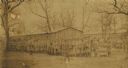
| Description: | Large group of Union soldiers in formation by a barracks at Camp Douglas in Chicago, Illinois. |
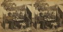
| Date: | 1862 |
|---|---|
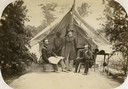
| Description: | Stereograph of Union officers eating a meal in camp. |
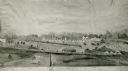
| Date: | 1862 |
|---|---|
| Description: | Photograph of a watercolor of a view of Camp Randall, from the northeast. Scene set on rolling hills, shows tents, buildings, horses and military members i... |
| Date: | 1862 |
|---|---|
| Description: | "Camp Casey near Fairfax Seminary, Virginia 1st Brigade, Casey's Division". Handcolored lithograph of site of Camp Casey. |
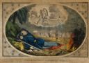
| Date: | 1862 |
|---|---|
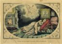
| Description: | "The Soldier's Dream of Home," a Currier and Ives lithograph, handcolored. |
| Date: | 1862 |
|---|---|
| Description: | "The Soldier's Home, the Vision," a Currier and Ives lithograph, handcolored. |

| Date: | 1862 |
|---|---|
| Description: | Non-commissioned officers of Company C of the 2nd Wisconsin. From left to right they are W.S. Rouse, R. Ash, G.E. Smith, N.H. Whittemore, O.F. Crary, and J... |

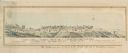
| Date: | 1862 |
|---|---|
| Description: | Birds-eye view of a Wisconsin Civil War regiment on parade in Fond du Lac, as drawn by Louis Kurz from the Marr Street Methodist Church. The regiment canno... |
| Date: | 1862 |
|---|---|
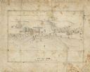
| Description: | A small amateur drawing of the camp, with surrounding terrain, occupied by the 104th Regiment, New York State Volunteers near Belle Plains, Virginia, durin... |

| Date: | 1862 |
|---|---|
| Description: | This map of the Battle of Shiloh shows relief by hachures, vegetation, drainage, houses, fields, fences, mills, and roads and is color coded to show the mo... |
| Date: | 1862 |
|---|---|
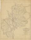
| Description: | This map of the area between Monterey, Tennessee, and Corinth, Mississippi, shows Union lines of entrenchment in blue and Confederate lines around Corinth ... |

| Date: | 1862 |
|---|---|
| Description: | This detailed map shows batteries and rifle pits, railroads, common and military roads, turnpikes, city streets and names, bridges, ferries, rural houses a... |
If you didn't find the material you searched for, our Library Reference Staff can help.
Call our reference desk at 608-264-6535 or email us at: