 Filter: Categories of Wisconsin Historical Images
Filter: FULL_DATE of 1862
Filter: Subject of church buildings
Filter: Categories of Wisconsin Historical Images
Filter: FULL_DATE of 1862
Filter: Subject of church buildings
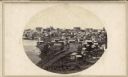
| Date: | 1862 |
|---|---|
| Description: | John S. Fuller took this image of the third Wisconsin State Capitol (the second in Madison), from Governor Farwell's Octagon House, probably early in 1862.... |
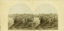
| Date: | 1862 |
|---|---|
| Description: | The third Wisconsin State Capitol (the second in Madison), from Governor Farwell's Octagon House, probably early in 1862. Also visible in the downtown are ... |

| Date: | 1862 |
|---|---|
| Description: | This 1862 map of Sheboygan County, Wisconsin, shows land ownership and acreages, the township and range grid, towns, cities and villages, roads, railroads,... |

| Date: | 1862 |
|---|---|
| Description: | This map shows townships and sections, landownership and acreages, roads, railroads, cemeteries, churches, schools, mills, and stone quarries. "Engraved, p... |

| Date: | 1862 |
|---|---|
| Description: | Shows townships and sections, landownership and acreage, roads, railroads, churches, schools, and cemeteries. Inset maps: Plat of Hingham -- Plat of Casca... |
If you didn't find the material you searched for, our Library Reference Staff can help.
Call our reference desk at 608-264-6535 or email us at: