 Filter: Categories of Wisconsin Historical Images
Filter: FULL_DATE of 1859
Filter: Year of 1800-1899
Filter: Subject of water
Filter: Categories of Wisconsin Historical Images
Filter: FULL_DATE of 1859
Filter: Year of 1800-1899
Filter: Subject of water
| Date: | 1859 |
|---|---|
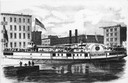
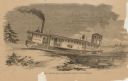
| Description: | Lithograph from Frank Leslie's Illustrated News of the sidewheel passenger, Lady Elgin, at her wharf in Chicago, Illinois in 1860. From a pho... |
| Date: | 1859 |
|---|---|
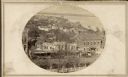
| Description: | South Pinckney Street as photographed by Fuller from the Wisconsin State Capitol roof. In the center are several wooden structures dating from Madison's e... |
| Date: | 1859 |
|---|---|
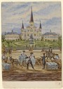
| Description: | On an excursion to the South in November 1859, Hölzlhuber made the three-day trip on the steamboat Planet from St. Louis to New Orleans. In the harb... |

| Date: | 1859 |
|---|---|
| Description: | Color drawing of beavers working on and living at their dams. |
| Date: | 1859 |
|---|---|
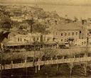
| Description: | Madison's Pinckney Street, with the Capitol Park in the foreground and Farwell's octagon house and Lake Monona in the distance. This view has been various... |

| Date: | 1859 |
|---|---|
| Description: | Map featuring various views of buildings and scenes from Sauk County. |

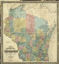
| Date: | 1859 |
|---|---|
| Description: | This 1859 railroad map shows counties, cities, rivers and lakes in the entire state of Wisconsin. It includes an inset depicting the railroads in Milwaukee... |
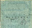
| Date: | 1859 |
|---|---|
| Description: | Detail of section 5 of the Washington County map showing only Hartford. |
| Date: | 1859 |
|---|---|
| Description: | 1859 sectional map of the state of Wisconsin. |

| Date: | 1859 |
|---|---|
| Description: | This map of the entire state of Wisconsin depicts the township survey grid and identifies counties, named towns, cities and villages, rivers, lakes, railro... |

| Date: | 1859 |
|---|---|
| Description: | This map, which includes eastern Iowa and northern Illinois but omits the northern and northwestern tiers of counties in Wisconsin, shows the township surv... |

| Date: | 1859 |
|---|---|
| Description: | This 1859 map of Washington County, Wisconsin, shows the township and range grid, towns, sections, landownership and acreages, cities and villages, roads, ... |

| Date: | 1859 |
|---|---|
| Description: | Shows townships and sections, landownership, roads, railroads, rural residences, schools, churches, and topography. Relief shown by hachures. "From governm... |

| Date: | 1859 |
|---|---|
| Description: | This map show plats including plat names, plat numbers, and some lot owner's names. Relief is shown by hachures. The map includes line drawings of Juneau B... |

| Date: | 1859 |
|---|---|
| Description: | This hand-colored map shows township and range in pink, blue, yellow, and orange, land ownership, includes 16 city inset maps showing land ownership, and 5... |
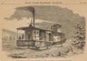
| Date: | 1859 |
|---|---|
| Description: | Engraved drawing of Norman Wiard's ice locomotive, the Lady Franklin operating on a frozen river. Male passengers and crew members are standing on t... |
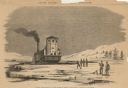
| Date: | 1859 |
|---|---|
| Description: | Engraved drawing of Norman Wiard's ice locomotive, Lady Franklin being pulled from water onto ice using its anchor. The vessel was built, but never ... |
| Date: | 1859 |
|---|---|
| Description: | Engraved drawing of Norman Wiard's ice locomotive, Lady Franklin leaving a snowy riverbank and entering the frozen river. The vessel was built, but ... |
If you didn't find the material you searched for, our Library Reference Staff can help.
Call our reference desk at 608-264-6535 or email us at: