 Filter: Categories of Wisconsin Historical Images
Filter: FULL_DATE of 1859
Filter: Subject of indians of north america
Filter: Categories of Wisconsin Historical Images
Filter: FULL_DATE of 1859
Filter: Subject of indians of north america

| Date: | 1859 |
|---|---|
| Description: | This map of the entire state of Wisconsin depicts the township survey grid and identifies counties, named towns, cities and villages, rivers, lakes, railro... |

| Date: | 1859 |
|---|---|
| Description: | This map, which includes eastern Iowa and northern Illinois but omits the northern and northwestern tiers of counties in Wisconsin, shows the township surv... |
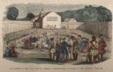
| Date: | 1859 |
|---|---|
| Description: | Hand-colored engraving showing fur company agents making a distribution of goods to Indians, some of whom are seated on the ground, in a fenced courtyard w... |
If you didn't find the material you searched for, our Library Reference Staff can help.
Call our reference desk at 608-264-6535 or email us at: