 Filter: Categories of Wisconsin Historical Images
Filter: FULL_DATE of 1859
Filter: Subject of architecture
Filter: Categories of Wisconsin Historical Images
Filter: FULL_DATE of 1859
Filter: Subject of architecture
| Date: | 1859 |
|---|---|
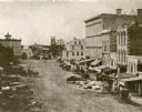
| Description: | Daguerreotype of elevated view of Pinckney Street, looking northwest. View includes the American House and Bruen's Block, both on the corner of East Washin... |
| Date: | 1859 |
|---|---|
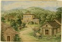
| Description: | Due to rainy weather, Hölzlhuber stayed a night in the home of Heinrich Cordes, who had purchased his land from an Irishman and built "a pretty brick house... |
| Date: | 1859 |
|---|---|
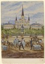
| Description: | On an excursion to the South in November 1859, Hölzlhuber made the three-day trip on the steamboat Planet from St. Louis to New Orleans. In the harb... |
| Date: | 1859 |
|---|---|
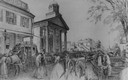
| Description: | City Hall in the background of a bustling street, with pedestrians, horses, carriages, and wagons. A stagecoach is parked across the street on the left. |
| Date: | 1859 |
|---|---|
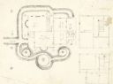
| Description: | An original pencil sketch by banker and real estate developer Napoleon B. Van Slyke, possibly for his residence erected in 1859 at 510 North Carroll Street... |
| Date: | 1859 |
|---|---|
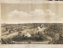
| Description: | Elevated view of the fairgrounds in Milwaukee, the year when Abraham Lincoln spoke. The fairgrounds were located at the Brockway Grounds near Twelfth and S... |

| Date: | 1859 |
|---|---|
| Description: | A drawing of the private Haskell University that was operating during the 1850's. The drawing was done by a student, Mrs. L. Campbell who spelled the name ... |

| Date: | 1859 |
|---|---|
| Description: | Map featuring various views of buildings and scenes from Sauk County. |

| Date: | 1859 |
|---|---|
| Description: | This 1859 map of Washington County, Wisconsin, shows the township and range grid, towns, sections, landownership and acreages, cities and villages, roads, ... |

| Date: | 1859 |
|---|---|
| Description: | Shows townships and sections, landownership, roads, railroads, rural residences, schools, churches, and topography. Relief shown by hachures. "From governm... |

| Date: | 1859 |
|---|---|
| Description: | This map show plats including plat names, plat numbers, and some lot owner's names. Relief is shown by hachures. The map includes line drawings of Juneau B... |
| Date: | 1859 |
|---|---|
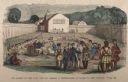
| Description: | Hand-colored engraving showing fur company agents making a distribution of goods to Indians, some of whom are seated on the ground, in a fenced courtyard w... |
| Date: | 1859 |
|---|---|
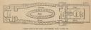
| Description: | Floorplan of Norman Wiard's ice locomotive, the Lady Franklin showing the locations of seating, water closets, ladies' salon, boiler, engine room, e... |
If you didn't find the material you searched for, our Library Reference Staff can help.
Call our reference desk at 608-264-6535 or email us at: