 Filter: Categories of Wisconsin Historical Images
Filter: FULL_DATE of 1858
Filter: Subject of roads
Filter: Categories of Wisconsin Historical Images
Filter: FULL_DATE of 1858
Filter: Subject of roads
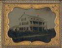
| Date: | 1858 |
|---|---|
| Description: | Ambrotype of the Wade House, a carriage inn located in Greenbush, also showing a section of the original plank road in the foreground. |
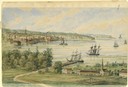
| Date: | 1858 |
|---|---|
| Description: | View from the second story of the Salesianum, the residence of Dr. Salzmann. The view includes Lake Michigan, the Milwaukee shoreline, and some of the nume... |
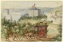
| Date: | 1858 |
|---|---|
| Description: | Hölzlhuber received a request from the German theater director Henry Börnstein in St. Louis, Missouri, to purchase his theater sets and music. Accordingly,... |

| Date: | 1858 |
|---|---|
| Description: | An ambrotype of Wonewoc. A road and fence is in the foreground, with houses beyond. A tree-lined hill is in the background. |

| Date: | 1858 |
|---|---|
| Description: | Drawn a decade after Wisconsin entered statehood, this 1858 map depicts counties, creeks, rivers, lakes, railroads completed, railroads in progress and com... |

| Date: | 1858 |
|---|---|
| Description: | This map of the entire state of Wisconsin depicts the township survey grid and identifies counties, named towns, cities and villages, rivers, lakes, railro... |

| Date: | 1858 |
|---|---|
| Description: | An ink on paper map of Milwaukee County and the eastern portion of Waukesha County that shows the townships of Oak Creek, Franklin, Greenfield, Wauwatosa, ... |

| Date: | 1858 |
|---|---|
| Description: | This 1858 map of Racine County, Wisconsin, shows land ownership and acreages, the township and range grid, towns, cities and villages, roads, railroads, sc... |

| Date: | 1858 |
|---|---|
| Description: | Map showing roads, mills, and rivers. Date conjectured from presence of Ensign’s Mill and Pitt’s Mill and location of Nekoosa. |

| Date: | 1858 |
|---|---|
| Description: | This 1858 map of Rock County, Wisconsin, shows the township and range grid, towns, sections, cities and villages, railroads, roads, property owners and res... |

| Date: | 1858 |
|---|---|
| Description: | Map shows township borders, marshes, pine timber, roads, railroads, and mills. The townships are are shown in blue/green, pink, and yellow. The map include... |

| Date: | 1858 |
|---|---|
| Description: | This map shows lot and block numbers, landownership, buildings, railroads, roads, wards, points of interest, parks, and cemeteries. Also included are illus... |
If you didn't find the material you searched for, our Library Reference Staff can help.
Call our reference desk at 608-264-6535 or email us at: