 Filter: Categories of Wisconsin Historical Images
Filter: FULL_DATE of 1858
Filter: Subject of land
Filter: Subject of rivers
Filter: Categories of Wisconsin Historical Images
Filter: FULL_DATE of 1858
Filter: Subject of land
Filter: Subject of rivers
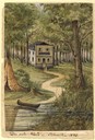
| Date: | 1858 |
|---|---|
| Description: | This house, built on a hill close to the Milwaukee River, was the only one in the city as late as 1840. The owner of the house, Martin [Matthias] Stein, a ... |
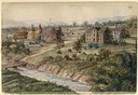
| Date: | 1858 |
|---|---|
| Description: | Hölzlhuber located this farm at about three German miles from Stevens Point. The region's soil was quite fertile. A wooden dwelling house stood in the mids... |
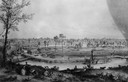
| Date: | 1858 |
|---|---|
| Description: | Lithograph view of river with a riverboat on the river, and a family on a hill above the river. There is a wagon or cart on the road below the hill. |

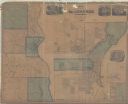
| Date: | 1858 |
|---|---|
| Description: | Drawn a decade after Wisconsin entered statehood, this 1858 map depicts counties, creeks, rivers, lakes, railroads completed, railroads in progress and com... |

| Date: | 1858 |
|---|---|
| Description: | This map shows the township survey grid and identifies counties, named towns, cities and villages, rivers, lakes, and railroads and proposed railroads in W... |

| Date: | 1858 |
|---|---|
| Description: | This map of the entire state of Wisconsin depicts the township survey grid and identifies counties, named towns, cities and villages, rivers, lakes, railro... |

| Date: | 1858 |
|---|---|
| Description: | This map shows lot and block numbers, landownership, buildings, railroads, roads, wards, points of interest, parks, and cemeteries. Also included are illus... |

| Date: | 1858 |
|---|---|
| Description: | This map shows city wards, streets, block and lot numbers, cemeteries, buildings, landownership, forests, railroads, a race course, quarries, and orchards.... |

| Date: | 1858 |
|---|---|
| Description: | This map shows the depth of the West Channel and the different types of minerals that make up the floor bed. The steamboat range station is labeled. A note... |
| Date: | 1858 |
|---|---|
| Description: | This map made up of six panels shows communities, rivers, and Lake Michigan. The map includes several inset maps showing Milwaukee, Humboldt, Franklin, Oak... |
If you didn't find the material you searched for, our Library Reference Staff can help.
Call our reference desk at 608-264-6535 or email us at: