 Filter: Categories of Wisconsin Historical Images
Filter: FULL_DATE of 1856
Filter: Subject of transportation
Filter: Categories of Wisconsin Historical Images
Filter: FULL_DATE of 1856
Filter: Subject of transportation

| Date: | 1856 |
|---|---|
| Description: | A map showing rail lines in Wisconsin and the railroad land grants of the Superior & St. Croix Railroad in the present-day northwestern Wisconsin counties ... |

| Date: | 1856 |
|---|---|
| Description: | A hand-colored map of Wisconsin, showing the county boundaries, towns, cities, railroads, roads, lakes, rivers, bays, and the Lake Superior’s islands. In ... |

| Date: | 1856 |
|---|---|
| Description: | This map shows the entire state of Wisconsin with counties, cities and rivers. It includes an inset of the layout of the streets of Milwaukee and a chart w... |
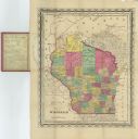
| Date: | 1856 |
|---|---|
| Description: | This map shows the state of Wisconsin in 1856. Counties in existence at the time and the division of townships, railroads, both existing and proposed, and ... |
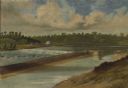
| Date: | 1856 |
|---|---|
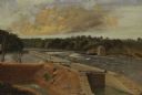
| Description: | "The second view at the Kakalin, from the north side of the river, shows the first or guard lock in the foreground and beyond the dam the large frame build... |
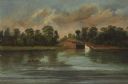
| Date: | 1856 |
|---|---|
| Description: | "Three views in a short space show the peaceful appearance of what is now a busy paper mills center. The first, a double lock around which the village of C... |
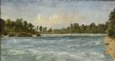
| Date: | 1856 |
|---|---|
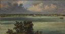
| Description: | "....The third view was twelve miles farther up the river [from De Pere], at Rapid Croche, on the border of the present Brown and Outagamie counties. It is... |
| Date: | 1856 |
|---|---|
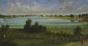
| Description: | " . . . The first in their series was not an 'improvement' but a view of the Green Bay settlement, looking downstream. From a simulated rustic fence corner... |
| Date: | 1856 |
|---|---|
| Description: | " . . . At Grand Chute stood the young settlement of Appleton. Although only a few years old, it already boasted a college, named, as was the village itsel... |
| Date: | 1856 |
|---|---|
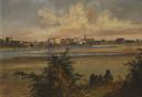
| Description: | ". . . At De Pere they stopped on the west shore for a broad sketch of the dwellings clustered on both sides of the river. The distant dam, the mills, ware... |

| Date: | 1856 |
|---|---|
| Description: | ". . . The upper Grand Chute was the last of the 'improvements' paintings signed by Brookes and Stevenson. Yet there were two more vital links in the Fox R... |
| Date: | 1856 |
|---|---|
| Description: | "After painting a number of Fox River scenes, "the artists continued their way to Fond du Lac, at the south end of Lake Winnebago, where they found some mo... |

| Date: | 1856 |
|---|---|
| Description: | This map with an ornamental border shows the township survey grid and identifies counties, named towns, cities and villages, rivers, lakes, railroads, road... |

| Date: | 1856 |
|---|---|
| Description: | This map of shows the township survey grid and identifies counties, named towns, cities and villages, rivers, lakes, railroads, roads, and the Menomonee an... |

| Date: | 1856 |
|---|---|
| Description: | This map depicts the route of the La Crosse and Milwaukee Railroad in Wisconsin. Other railroads in Wisconsin, northern Michigan, and northern Illinois wit... |

| Date: | 1856 |
|---|---|
| Description: | This map of Bayfield shows a plat of the town, roads, and part of Lake Superior. Relief is shown by hachures. The right margin of the map includes illustra... |

| Date: | 1856 |
|---|---|
| Description: | This map of Brohead shows land and lot ownerships by name and color, as well as roads, and railroads. |

| Date: | 1856 |
|---|---|
| Description: | This map of Woodman's Addition in Mineral Point is pen-and-ink on paper. The map includes certifications signed by John B. Whitelaw (surveyor), Cyrus Woodm... |

| Date: | 1856 |
|---|---|
| Description: | This map of the City of La Crosse is a plat of Pike & Co's Addition. The map shows street names, block and lot numbers, the South La Crosse River, and the ... |

| Date: | 1856 |
|---|---|
| Description: | This map shows a plat of town, local streets, and parts of East and Fox Rivers. |
If you didn't find the material you searched for, our Library Reference Staff can help.
Call our reference desk at 608-264-6535 or email us at: