 Filter: Categories of Wisconsin Historical Images
Filter: FULL_DATE of 1856
Filter: Type of Map or Atlas
Filter: Subject of rivers
Filter: Categories of Wisconsin Historical Images
Filter: FULL_DATE of 1856
Filter: Type of Map or Atlas
Filter: Subject of rivers

| Date: | 1856 |
|---|---|
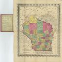
| Description: | A hand-colored map of Wisconsin, showing the county boundaries, towns, cities, railroads, roads, lakes, rivers, bays, and the Lake Superior’s islands. In ... |

| Date: | 1856 |
|---|---|
| Description: | This map shows the entire state of Wisconsin with counties, cities and rivers. It includes an inset of the layout of the streets of Milwaukee and a chart w... |
| Date: | 1856 |
|---|---|
| Description: | This map shows the state of Wisconsin in 1856. Counties in existence at the time and the division of townships, railroads, both existing and proposed, and ... |

| Date: | 1856 |
|---|---|
| Description: | This map with an ornamental border shows the township survey grid and identifies counties, named towns, cities and villages, rivers, lakes, railroads, road... |

| Date: | 1856 |
|---|---|
| Description: | This map of shows the township survey grid and identifies counties, named towns, cities and villages, rivers, lakes, railroads, roads, and the Menomonee an... |

| Date: | 1856 |
|---|---|
| Description: | This map depicts the route of the La Crosse and Milwaukee Railroad in Wisconsin. Other railroads in Wisconsin, northern Michigan, and northern Illinois wit... |

| Date: | 1856 |
|---|---|
| Description: | This map of Brohead shows land and lot ownerships by name and color, as well as roads, and railroads. |

| Date: | 1856 |
|---|---|
| Description: | This map of the City of La Crosse is a plat of Pike & Co's Addition. The map shows street names, block and lot numbers, the South La Crosse River, and the ... |

| Date: | 1856 |
|---|---|
| Description: | This map shows a plat of town, local streets, and parts of East and Fox Rivers. |

| Date: | 1856 |
|---|---|
| Description: | This map shows a plat of the town, local streets, lots, and part of the Rock River. The margins of the map have manuscript annotations in ink. |

| Date: | 1856 |
|---|---|
| Description: | This map shows plat of town, local streets, railroads, projected railroads, residential buildings, mills, and part of the Crawfish River. The map includes ... |

| Date: | 1856 |
|---|---|
| Description: | This map shows lot and block numbers, wards, roads, railroads, and some landowner names. Lake Michigan and the Milwaukee River are labeled. Includes an ins... |

| Date: | 1856 |
|---|---|
| Description: | This map shows lot and block numbers, streets, a mill, the Milwaukee and Mississippi Railroad, the train depot, and the Kickapoo River. Included in the low... |
| Date: | 1856 |
|---|---|
| Description: | This map is ink and watercolor on paper and includes certifications inscribed by Saml. T. [M?]ight, a civil engineer, Edward H. Brodhead, James H. Lockwood... |

| Date: | 1856 |
|---|---|
| Description: | This map is ink and color on paper and mounted on cloth. The map shows lot and block numbers, streets, a railroad, and the Kickapoo River. Some lots are c... |

| Date: | 1856 |
|---|---|
| Description: | This map shows the Manitowoc River, Lake Michigan, streets, and buildings. Relief is shown by hachures and soundings are in feet and decimals of a foot. Th... |

| Date: | 1856 |
|---|---|
| Description: | This map shows streets, piers, and wharves. Lake Michigan, the Manitowoc River, and select buildings are labeled. Relief is shown by hachures and sounding... |

| Date: | 1856 |
|---|---|
| Description: | This map shows the railroad routes and connection of the Mineral Point Railroad. Lake Michigan is on the far right, while Lake Superior is at the top of th... |

| Date: | 1856 |
|---|---|
| Description: | This map shows the railroad routes that lead to Milwaukee. Included are portions of Minnesota, Iowa and Illinois. Lake Michigan is on the right, while Lake... |
| Date: | 1856 |
|---|---|
| Description: | This map shows township grids, existing settlements, Indian reservations, rivers, lakes, and treaty lines. Included is a portion of Minnesota. Lake Michiga... |
If you didn't find the material you searched for, our Library Reference Staff can help.
Call our reference desk at 608-264-6535 or email us at: