 Filter: Categories of Wisconsin Historical Images
Filter: FULL_DATE of 1855
Filter: Subject of human settlements
Filter: Community of Milwaukee
Filter: Categories of Wisconsin Historical Images
Filter: FULL_DATE of 1855
Filter: Subject of human settlements
Filter: Community of Milwaukee
| Date: | 1855 |
|---|---|
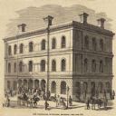
| Description: | Clipping from a newspaper or magazine. Building on a corner with a Post Office sign on left side of building, Custom House sign on the right side. Horse-... |
| Date: | 1855 |
|---|---|
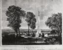
| Description: | Lithograph showing the projected plan for the memorial. Monument is on top of a hill, looking out over the city, with a fenced off park area. Seven people ... |

| Date: | 1855 |
|---|---|
| Description: | Pen-and-ink on paper. Includes certifications signed by surveyor and by "John T. Perkins, by his attorney I.A. Lapham." Inscribed and signed certification ... |

| Date: | 1855 |
|---|---|
| Description: | This map shows lot and block numbers, buildings, some landownership, roads, railroads, cemeteries, the Milwaukee River, and Lake Michigan. The map includes... |
| Date: | 1855 |
|---|---|
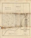
| Description: | This map shows plat of town, local streets, numbered blocks and lots, proposed city park, Murray’s addition, and part of Lake Michigan. Also includes a tab... |
If you didn't find the material you searched for, our Library Reference Staff can help.
Call our reference desk at 608-264-6535 or email us at: