 Filter: Categories of Wisconsin Historical Images
Filter: FULL_DATE of 1854
Filter: Subject of superior, lake
Filter: Categories of Wisconsin Historical Images
Filter: FULL_DATE of 1854
Filter: Subject of superior, lake

| Date: | 1854 |
|---|---|
| Description: | Drawing of the Porcupine Mountains on Lake Superior. A deer is standing in the lake drinking water. A man is on the rock ledge above the shoreline and is a... |
| Date: | 1854 |
|---|---|
| Description: | This map shows portions of present-day Iron and Vilas counties north of the Manitowish River as part of the Upper Peninsula of Michigan. The Wisconsin coun... |

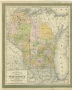
| Date: | 1854 |
|---|---|
| Description: | Brightly-colored map exhaustively marks the townships, County Towns and villages of Wisconsin. It also shows rivers, canals, railroads, and plank roads. Ea... |

| Date: | 1854 |
|---|---|
| Description: | This map shows proposed counties in northern Wisconsin included Douglas, La Pointe, Polk, Chippewa, Dunn, St. Croix, Pierce and Clark. This map shows the p... |

| Date: | 1854 |
|---|---|
| Description: | This map is mounted on cloth and shows lot and block numbers, streets, additions, and public squares. Also included is information on Trempealeau, an inset... |

| Date: | 1854 |
|---|---|
| Description: | This map shows the Manitowoc & Mississippi Railroad line along with other railroad lines in the Great Lakes Region. Lakes Superior, Michigan, Huron, Erie a... |

| Date: | 1854 |
|---|---|
| Description: | A sketch of the public surveys of Wisconsin and territory of Minnesota. |
If you didn't find the material you searched for, our Library Reference Staff can help.
Call our reference desk at 608-264-6535 or email us at: