 Filter: Categories of Wisconsin Historical Images
Filter: FULL_DATE of 1854
Filter: Creator Name of Mitchell, Samuel Augustus
Filter: Categories of Wisconsin Historical Images
Filter: FULL_DATE of 1854
Filter: Creator Name of Mitchell, Samuel Augustus
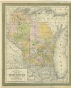
| Date: | 1854 |
|---|---|
| Description: | This map shows portions of present-day Iron and Vilas counties north of the Manitowish River as part of the Upper Peninsula of Michigan. The Wisconsin coun... |
If you didn't find the material you searched for, our Library Reference Staff can help.
Call our reference desk at 608-264-6535 or email us at: