 Filter: Categories of Wisconsin Historical Images
Filter: FULL_DATE of 1852
Filter: Subject of land
Filter: County of Dane
Filter: Categories of Wisconsin Historical Images
Filter: FULL_DATE of 1852
Filter: Subject of land
Filter: County of Dane

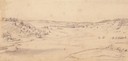
| Date: | 1852 |
|---|---|
| Description: | Pencil drawing of Madison landscape as seen from University Hill. The main street in the center is State Street, and the building with Greek columns in the... |

| Date: | 1852 |
|---|---|
| Description: | Pencil drawing of view overlooking Madison. The sketch looks down North Hamilton Street from the capitol. Rutted, irregular streets and frame houses mark ... |
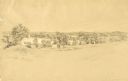
| Date: | 1852 |
|---|---|
| Description: | Pencil drawing of Black Earth Valley. Gentle lightly tree-covered hills frame the center grassy valley. Two farmhouses are sitting at the base of hills on ... |
| Date: | 1852 |
|---|---|
| Description: | Pencil drawing of trees around the shore of a lake from across a field. |

| Date: | 1852 |
|---|---|
| Description: | On left side map reads: "Note by the lithographer on the Original Plat there is a Certificate of Record signed by Resister of Dane Co. also a Certificate o... |
| Date: | 1852 |
|---|---|
| Description: | View down a road lined with trees. Two people in a horse-drawn vehicle are moving down the road. Caption reads: "Unidientified road in the vicinity of Madi... |
If you didn't find the material you searched for, our Library Reference Staff can help.
Call our reference desk at 608-264-6535 or email us at: