 Filter: Categories of Wisconsin Historical Images
Filter: FULL_DATE of 1850
Filter: Subject of water
Filter: Categories of Wisconsin Historical Images
Filter: FULL_DATE of 1850
Filter: Subject of water

| Date: | 1850 |
|---|---|
| Description: | A map which includes the ink and pencil annotations showing the sections, sold parcels of land, and streams and lakes on a printed township base map for To... |

| Date: | 1850 |
|---|---|
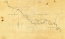
| Description: | Map is pen and pencil on paper. The map shows roads, creeks, and the Chequamegon Bay. The map is undated and prepared sometime between the establishment of... |
| Date: | 1850 |
|---|---|
| Description: | The map is ink on tracing cloth. The map shows portions of township 20 north, range 12 east, section 30 (in the Town of Saxeville) and township 20 north, r... |

| Date: | 1850 |
|---|---|
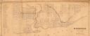
| Description: | This map of Cassville shows plat of town, roads, and the Mississippi River. Relief is shown by hachures. The map includes an inset map of a Plat of townshi... |

| Date: | 1850 |
|---|---|
| Description: | This map of Cassville shows plat of the town, roads, landings and public wharfs and the Mississippi River. |

| Date: | 1850 |
|---|---|
| Description: | This map of the Town of Lake is ink and pencil on paper and shows lots and acreages, reserved land, and public squares. The bottom of the map includes a ke... |

| Date: | 1850 |
|---|---|
| Description: | This map of Geneva shows lots and acreages, reserved land, and public squares. Streets and Lake Geneva are labeled. The map includes manuscript annotations... |
| Date: | 1850 |
|---|---|
| Description: | This map shows a plat of city, land ownership by name, local streets, roads, and part of Willow River and Lake St. Croix. The map is indexed by additions a... |

| Date: | 1850 |
|---|---|
| Description: | This map shows a plat of the town, land owners by name, local streets, railroads, churches, and part of the Rock River. The map is also indexed by church d... |
| Date: | 1850 |
|---|---|
| Description: | This map shows a cross-section of southern Wisconsin, with the Milwaukee and Mississippi Railroad line running from Milwaukee to the Mississippi River near... |

| Date: | 1850 |
|---|---|
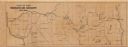
| Description: | This series of maps shows townships, ranges, sections, lakes, rivers, and roads. The maps cover areas between Township No. 26 and Township No. 42. |

| Date: | 1850 |
|---|---|
| Description: | This map shows the location of planned blocks and lot numbers, street names, and docks along the Fox River and canal. |

| Date: | 1850 |
|---|---|
| Description: | This photocopied map shows lot and block numbers, selected buildings, street names and state lock located on the Fox River. Includes a description of Deper... |
| Date: | 1850 |
|---|---|
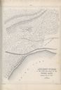
| Description: | A drawing of ancient works at the southeast angle of the Third Lake. |
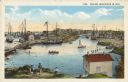
| Date: | 1850 |
|---|---|
| Description: | Text on front reads: "Racine, Wisconsin in 1850." Artist's rendering of the view of the harbor with sailing ships, sailboats, rowboats and canoes. The Main... |
If you didn't find the material you searched for, our Library Reference Staff can help.
Call our reference desk at 608-264-6535 or email us at: