 Filter: Categories of Wisconsin Historical Images
Filter: FULL_DATE of 1850
Filter: Subject of transportation
Filter: Subject of roads
Filter: Categories of Wisconsin Historical Images
Filter: FULL_DATE of 1850
Filter: Subject of transportation
Filter: Subject of roads
| Date: | 1850 |
|---|---|
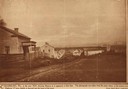
| Description: | Main Street in Cedarburg. Includes text which reads: "Cedarburg, Wis., in the year 1850, showing Main Street as it appeared at that time. The photograph wa... |
| Date: | 1850 |
|---|---|
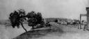
| Description: | Buildings along Wisconsin River. |

| Date: | 1850 |
|---|---|
| Description: | A hand-colored map showing portions of present-day Iron and Vilas counties north of the Manitowish River as part of the Upper Peninsula of Michigan. The Wi... |

| Date: | 1850 |
|---|---|
| Description: | This detailed map outlines mid and southern WI county boundaries in bright color, and city/town lines are provided. Other marks include lead mines, copper ... |

| Date: | 1850 |
|---|---|
| Description: | Mid and southern Wisconsin counties, city/town lines, lead mines, copper mines, streams, plank roads, and the Milwaukee and Mississippi Rail Roads. |

| Date: | 1850 |
|---|---|
| Description: | Map is pen and pencil on paper. The map shows roads, creeks, and the Chequamegon Bay. The map is undated and prepared sometime between the establishment of... |

| Date: | 1850 |
|---|---|
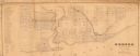
| Description: | This map of Cassville shows plat of the town, roads, landings and public wharfs and the Mississippi River. |
| Date: | 1850 |
|---|---|
| Description: | This map shows a plat of city, land ownership by name, local streets, roads, and part of Willow River and Lake St. Croix. The map is indexed by additions a... |
| Date: | 1850 |
|---|---|
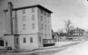
| Description: | A grist mill on the Yahara River at the outlet of Lake Mendota. The mill, called Farwell's Madison Mills was built in 1850 by Governor Farwell. The origina... |

| Date: | 1850 |
|---|---|
| Description: | This series of maps shows townships, ranges, sections, lakes, rivers, and roads. The maps cover areas between Township No. 26 and Township No. 42. |

| Date: | 1850 |
|---|---|
| Description: | This photocopied map shows lot and block numbers, selected buildings, street names and state lock located on the Fox River. Includes a description of Deper... |
If you didn't find the material you searched for, our Library Reference Staff can help.
Call our reference desk at 608-264-6535 or email us at: