 Filter: Categories of Wisconsin Historical Images
Filter: FULL_DATE of 1850
Filter: Subject of transportation
Filter: Creator Name of Unknown
Filter: Categories of Wisconsin Historical Images
Filter: FULL_DATE of 1850
Filter: Subject of transportation
Filter: Creator Name of Unknown
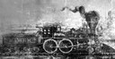
| Date: | 1850 |
|---|---|
| Description: | Drawing of an early locomotive that the Milwaukee and Mississippi Railroad rebuilt to run on the M.& M. R.R. line (which was later absorbed into the Chicag... |
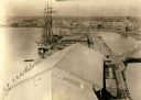
| Date: | 1850 |
|---|---|
| Description: | Elevated view of the Green Bay harbor and docks. |

| Date: | 1850 |
|---|---|
| Description: | Map is pen and pencil on paper. The map shows roads, creeks, and the Chequamegon Bay. The map is undated and prepared sometime between the establishment of... |

| Date: | 1850 |
|---|---|
| Description: | This map of Cassville shows plat of town, roads, and the Mississippi River. Relief is shown by hachures. The map includes an inset map of a Plat of townshi... |

| Date: | 1850 |
|---|---|
| Description: | This map of Cassville shows plat of the town, roads, landings and public wharfs and the Mississippi River. |

| Date: | 1850 |
|---|---|
| Description: | This map of Geneva shows lots and acreages, reserved land, and public squares. Streets and Lake Geneva are labeled. The map includes manuscript annotations... |

| Date: | 1850 |
|---|---|
| Description: | This map shows a plat of the town, land owners by name, local streets, railroads, churches, and part of the Rock River. The map is also indexed by church d... |
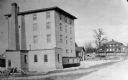
| Date: | 1850 |
|---|---|
| Description: | A grist mill on the Yahara River at the outlet of Lake Mendota. The mill, called Farwell's Madison Mills was built in 1850 by Governor Farwell. The origina... |
If you didn't find the material you searched for, our Library Reference Staff can help.
Call our reference desk at 608-264-6535 or email us at: