 Filter: Categories of Wisconsin Historical Images
Filter: FORMAT_TYPE of prints, photomechanical
Filter: Year of 1900-1999
Filter: County of Polk
Filter: Categories of Wisconsin Historical Images
Filter: FORMAT_TYPE of prints, photomechanical
Filter: Year of 1900-1999
Filter: County of Polk
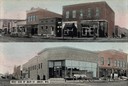
| Date: | 1905 |
|---|---|
| Description: | Top view is from the intersection looking towards buildings on the right side of the street. The bottom view has a caption that reads: "West Side of Main S... |

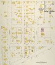
| Date: | 05 1926 |
|---|---|
| Description: | Section 1 of a Sanborn map of Osceola. |

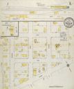
| Date: | 05 1926 |
|---|---|
| Description: | Section 2 of a Sanborn map of Osceola. |
| Date: | 05 1926 |
|---|---|
| Description: | Section 3 of a Sanborn map of Osceola. |

| Date: | 10 1911 |
|---|---|
| Description: | Section 1 of a Sanborn map of Osceola. |
| Date: | 10 1911 |
|---|---|
| Description: | Section 2 of a Sanborn Map of Osceola. |
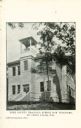
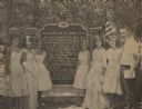
| Date: | 1905 |
|---|---|
| Description: | Exterior view of building with a bell tower. Caption reads: "Polk County Training School for Teachers, St. Croix Falls, Wis." |

| Date: | 1926 |
|---|---|
| Description: | A brochure with a map of Interstate Park on the Dalles of the Saint Croix River, showing locations of the north and south camp grounds, the fish hatcheries... |
| Date: | 1980 |
|---|---|
| Description: | This road map of Polk County, Wisconsin, has been annotated to show the location of historic sites in the county and is accompanied by a 1980 directory of ... |
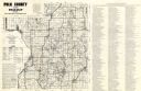
| Date: | 1900 |
|---|---|
| Description: | This map of Polk County, Wisconsin, from the early 20th century shows the land for sale by the Cushing Land Agency of Saint Croix Falls. The township and r... |

| Date: | 1911 |
|---|---|
| Description: | This map of Polk County, Wisconsin, from the early 20th century shows the land for sale by the Baker Land and Title Co. of Saint Croix Falls. The township ... |

| Date: | 1901 |
|---|---|
| Description: | Map shows townships, schools, creameries, post offices, and roads. The left side of the map features a legend with symbols for points of interest. |

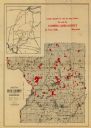
| Date: | 1914 |
|---|---|
| Description: | Map shows townships, schools, creameries, post offices, and roads. The left side of the map features a legend with symbols for points of interest. |

| Date: | 1969 |
|---|---|
| Description: | Map showing St. Croix Falls and Taylors Falls, Minnesota. The map was produced by the St. Croix Falls Chamber of Commerce and Taylor Falls Commercial Club.... |
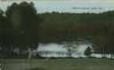
| Date: | 1910 |
|---|---|
| Description: | Colorized postcard view down hill toward the lake. Caption reads: "South Clear Lake, Wis." |

| Date: | 1960 |
|---|---|
| Description: | This blue line print map shows pipes, valves, well site, and elevation tank, as well as lot and block numbers and dimensions. The map includes inset of con... |
| Date: | 07 26 1964 |
|---|---|
| Description: | The newly crowned beauty queens and attendants from St. Croix Falls and neighboring Taylors Falls stand with Willis Erickson (right), president of the Polk... |
| Date: | 01 20 1916 |
|---|---|
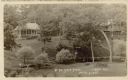
| Description: | Elevated view across lawn and river toward two buildings on a hill, including the main lodge on the right. A stairway leads down to the river on the right,... |
| Date: | 01 20 1916 |
|---|---|
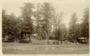
| Description: | Exterior view of the grounds at the Seven Pines Lodge. Three buildings are in the distance. Caption reads: "At The Seven Pines, Lewis, Wis." |
| Date: | 01 20 1916 |
|---|---|
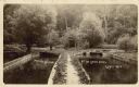
| Description: | Outdoor view of several divided ponds. |
If you didn't find the material you searched for, our Library Reference Staff can help.
Call our reference desk at 608-264-6535 or email us at: